
 Sinh Giang
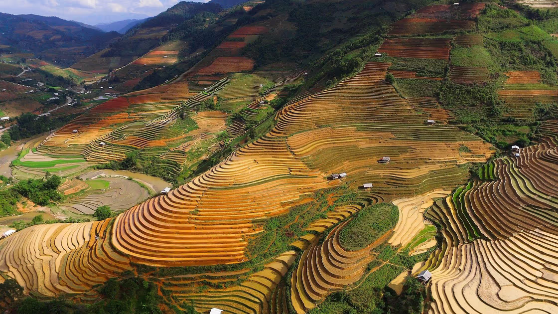
Pu Luong, Mai Chau and Mu Cang Chai are the three rice-terrace areas travellers most often weigh against each other when they want mountain scenery in northern Vietnam, and they are not interchangeable. Mai Chau is a valley about three hours from Hanoi where you sleep in a White Thai stilt house. Pu Luong is a nature reserve of terraces, limestone and forest, about 4.5 hours from the capital, that rewards two nights. Mu Cang Chai has the biggest terraced hillsides of the three and the longest road, around 300 km from Hanoi according to Vietnam’s national tourism portal.
The short answer: with two days, choose Mai Chau or Pu Luong; with four days in September, October or the flooded weeks of late May and early June, choose Mu Cang Chai; with a week, join Mai Chau and Pu Luong, which are 50 to 65 km apart. We run treks in Sapa, not in these three places, so we have nothing to sell you here. This is the decision page that our overview of Vietnam’s rice terraces does not have. We checked the facts on 31 October 2026 against the national tourism portal, the Pu Luong reserve authority, the government news site and the text of the 2025 provincial resolution, and we mark every number the sources disagree on.
Pu Luong, Mai Chau or Mu Cang Chai: The Short Answer
Pick Mai Chau for the easiest trip, Pu Luong for terraces mixed with forest and a slower pace, and Mu Cang Chai for the largest terraced hillsides if you can spend four days and travel in the right weeks. The three cards below put the practical differences side by side.
Mai Chau
The easy valley- Province now
- Phu Tho (formerly Hoa Binh), since 1 July 2025
- From Hanoi
- About 3 hours by car or bus via Hoa Binh (national tourism portal)
- Rice months
- Golden September to November; the portal also calls March to May pleasant
- What you see
- A flat valley of paddies around stilt-house villages, not stacked mountain terraces
- Where you sleep
- Simple White Thai homestays in Lac and Pom Coong
- Best for
- One night out of Hanoi, cycling, families, a first homestay
Pu Luong
Terraces and forest- Province now
- Thanh Hoa, unchanged in 2025
- From Hanoi
- About 160 km and 4.5 hours (national tourism portal); the reserve authority says about 210 km
- Rice months
- Green late May to June; golden September to October
- What you see
- Terraces between limestone peaks and forest, bamboo water wheels, streams
- Where you sleep
- Homestays and eco-lodges, many on stilts
- Best for
- Two nights, walkers and cyclists, a quieter pace
Mu Cang Chai
The big terraces- Province now
- Lao Cai (formerly Yen Bai), the same province as Sapa, since 1 July 2025
- From Hanoi
- About 300 km (national tourism portal); guides quote 5 to 8 hours depending on the vehicle
- Rice months
- Flooded late May to early June; golden September to October
- What you see
- About 2,200 hectares of terraced hillsides in three communes: La Pan Tan, Che Cu Nha and De Xu Phinh
- Where you sleep
- Homestays and guesthouses; we found no official list, so book ahead
- Best for
- Photographers, four days or more, September to October or the water weeks
Hours are by road. Mai Chau and Pu Luong come from the national tourism portal; the Mu Cang Chai range from a 2026 transport guide (car 5 to 7 hours, sleeper bus 7 to 8). A table below shows where sources disagree.
Where They Are Now: The 2025 Name Changes
Two of the three places changed province on 1 July 2025, and the district level of government disappeared with it, so older pages and maps disagree with newer ones. Resolution 202/2025/QH15, adopted on 12 June 2025, merged Yen Bai into Lao Cai province and merged Vinh Phuc, Hoa Binh and Phu Tho into Phu Tho province, and it lists Thanh Hoa among the provinces left unchanged. We read the English text of the resolution on 31 October 2026.
Mu Cang Chai was in Yen Bai province and is now in Lao Cai province, the same province as Sapa. Mai Chau was in Hoa Binh province and is now in Phu Tho province. Pu Luong stays in Thanh Hoa province. The government news site reports that the district level of administration ended on 1 July 2025, so “Mai Chau district”, “Ba Thuoc district” and “Mu Cang Chai district” still appear on older signs, maps and articles. We use the place names travellers still see on tickets and signs; the official commune names can differ.
Mai Chau: The Easy Valley, About Three Hours From Hanoi
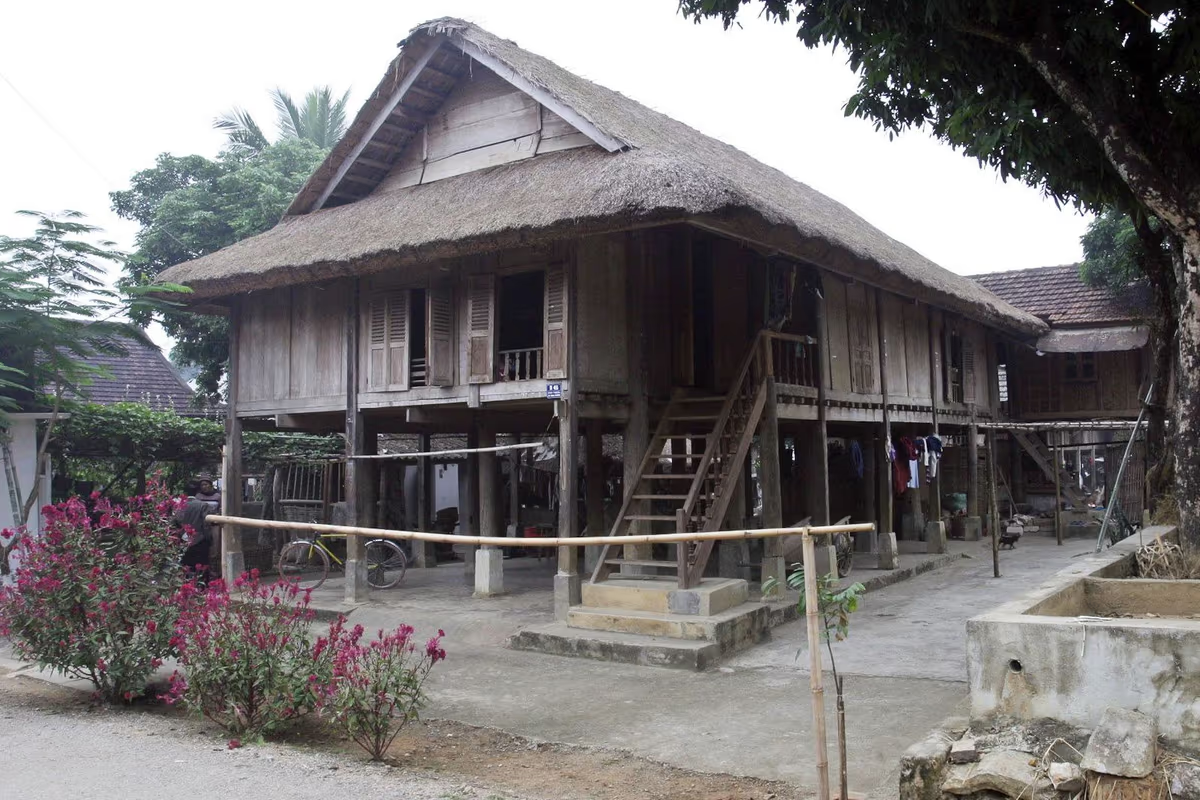
Mai Chau is the simplest of the three: about three hours by car or bus from Hanoi via Hoa Binh, with White Thai families offering homestays in stilt houses in the villages of Lac and Pom Coong, according to Vietnam’s national tourism portal (checked 31 October 2026). Commercial pages give 130 to 145 km, but the portal gives hours rather than kilometres, so we quote hours.
What You See
Mai Chau is a valley floor, not a terraced mountainside. The portal describes small ethnic-minority villages among a patchwork of paddy fields, with green mountains around them. Expect flat fields, narrow paths and limestone hills in the distance. If the picture in your head is a hillside carved into curved steps, that is Mu Cang Chai or Pu Luong. Our guide to day trips from Hanoi makes the same point: the valley is flat and easy to cycle, which suits families and first-time homestay guests.
The Stay
The portal calls the accommodation simple and lists what goes with it: home-cooked dinners with local families, cycling on quiet paths between clusters of stilt houses, handwoven fabrics from weavers on old looms (bargaining is expected) and a Sunday morning market where ethnic-minority people come in traditional dress. It also lists kayaking on Hoa Binh Lake and a visit to Pu Luong as day trips. If you have read about a Tay stilt house at Ban Ho near Sapa in our guide to the Tay people, the idea is similar, but the Thai and the Tay are separate peoples in Vietnam’s list of 54, with their own dress and traditions.
When to Go and How Long to Stay
The portal gives September to November as the best time, when the paddies turn golden and the days are cool and clear, with March to May also pleasant, and it says rain is heaviest from May to September. In our view, because the valley is small and flat, one night is enough for most visitors. A second night makes sense mainly if Mai Chau is your first stop on the way to Pu Luong.
Pu Luong: Terraces, Forest and Water Wheels, About 4.5 Hours Away
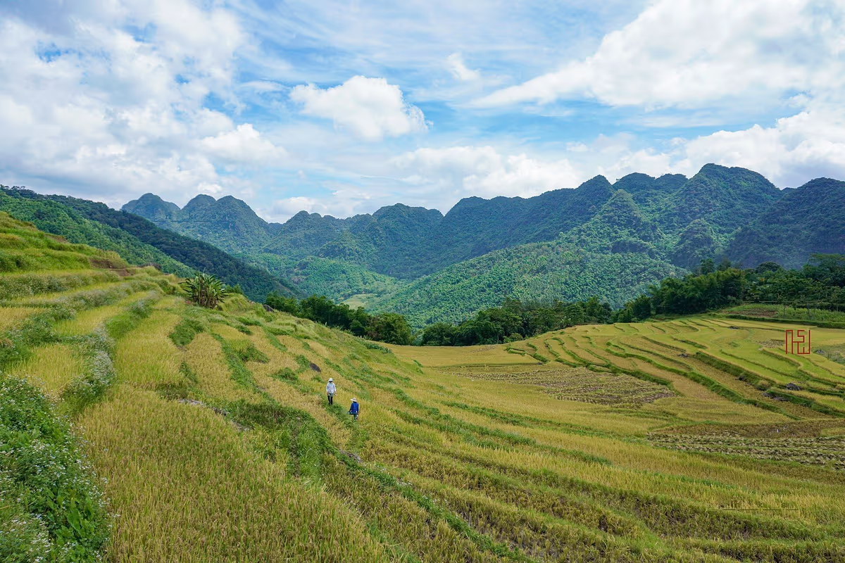
Pu Luong is a nature reserve in Thanh Hoa province where terraces sit between forest and limestone peaks, about 160 km and 4.5 hours southwest of Hanoi according to the national tourism portal, although the reserve’s own authority says about 210 km (both checked 31 October 2026). The reserve was established in 1999 and covers 17,662 hectares, of which 13,320 are strictly protected and 4,343 are an ecological restoration area. It spans ten communes, five in each of two former districts, Quan Hoa and Ba Thuoc.
What You Do There
The portal lists walking to hilltops with views over villages and valleys, cycling on mostly gentle roads (homestays often lend bicycles free), bamboo water wheels that lift stream water to the terraces, and Hieu Waterfall, a community-run site with five small falls where swimming is only possible occasionally. It mentions a peak of about 1,700 m with clouds and stilt houses below, and Pho Doan market, which serves Kinh, Muong and Thai communities. The people of the area are Thai and Muong. The reserve authority describes a seasonal tropical evergreen closed forest, so this is a place where the terraces are part of the scenery, not all of it.
Harvest Timing: Read This Before You Book
The reserve authority describes green fields from late May to early June and the golden, ripe-rice season in September and October. Another page of the national portal says the terraces turn a vibrant green from August until late October, and the photograph above shows ripening rice in early July. These do not contradict each other as much as they look: fields at different altitudes and in different villages are planted and cut at different times. Some operators sell June as a golden month. The official pages we opened call June green, so ask your host which fields are ripe in the week you plan to come.
Getting There and Staying
The portal says to allow about 4.5 hours, by hired car or motorbike or by limousine van from the Giap Bat or My Dinh stations in Hanoi, and it recommends breaking the journey at Ninh Binh or Mai Chau. Our Ninh Binh guide covers the first stop. Lodging is mostly homestays, from simple stilt houses in the terraces to a few retreats and lodges. The portal’s sustainable-stays page names Pu Luong Retreat, built by local carpenters with stilt houses and an infinity pool. We have not stayed in any of them, so we do not rate them. The national administration’s older Pu Luong page says hotels sit mainly in the buffer zone and budget homestays inside the reserve, so check what is current.
Mu Cang Chai: The Biggest Terraces and the Longest Road
Mu Cang Chai has the largest terraced hillsides of the three, about 2,200 hectares in the three communes of La Pan Tan, Che Cu Nha and De Xu Phinh according to the government news site, and it is the farthest from Hanoi, about 300 km according to the national tourism portal (both checked 31 October 2026). The portal’s page on rice terraces says the terraces cover more than 2,000 hectares and have been farmed by the H’mong for more than twenty generations.
A Protected Landscape
The terraces were rated a national relic by the Ministry of Culture, Sports and Tourism in 2007, and the government news site reported on 9 January 2020 that the Prime Minister had recognised them as a special national relic. We use the 2,200-hectare figure from that report; other pages quote different areas, and we could not reconcile them. This is working farmland, not a park, so you walk through other people’s fields.
The Two Seasons
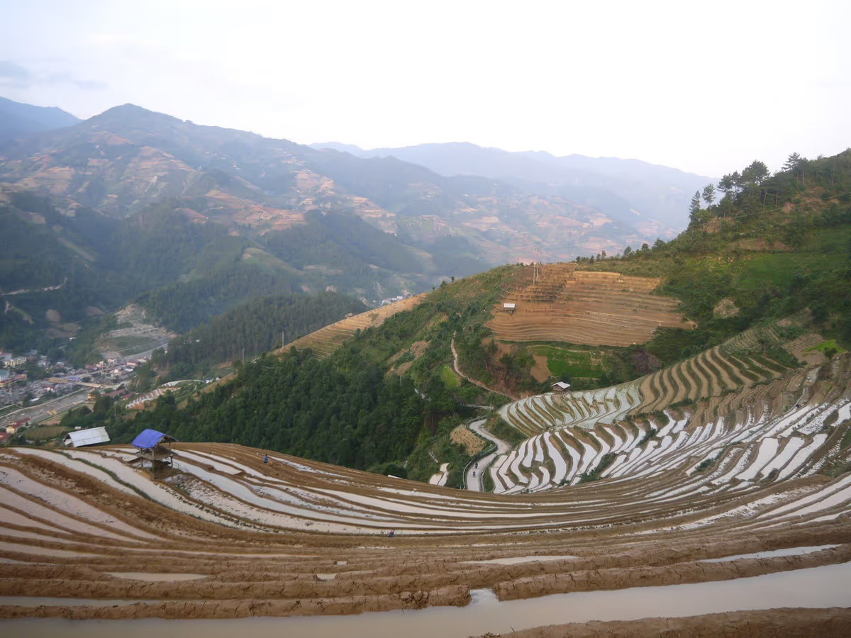
The portal gives late May to early June for the water-pouring season, when farmers direct water from the top of the mountain into the terraces and the hillsides become mirrors, and September to October for the golden season. Its page on the water season also tells readers to reserve the last week of April to the first week of May, which is the planting period, so the dates on that page are inconsistent with each other. We would plan for the end of May and the first half of June, and ask a local host a week before you go. The portal also mentions paragliding events at Khau Pha Pass, one in the planting season and one in the harvest season; we did not find 2026 or 2027 dates, so check them if they matter to you.
Getting There
The portal recommends buses from Hanoi, many of them sleeper coaches, notes there are no direct trains (daily trains reach Yen Bai, where you connect by bus) and says motorbiking is popular. The 2026 transport guide we used quotes bus fares of 300,000 to 550,000 VND one way, and warns that some buses drop you in Mu Cang Chai town or at other points along the route, so homestays near La Pan Tan may need another ride. It also says some bus services may be cancelled, so check schedules close to your date. Mam Xoi Hill is hard to reach, especially when it is wet, and the portal advises hiring a local driver.
Numbers That Disagree: Distances, Hours and Areas
Travel pages copy each other, and the figures for these three places do not agree. This table shows what we found and the wording we chose.
| Fact | Figures found | What we say |
|---|---|---|
| Hanoi to Mai Chau | About 3 hours (national portal, no distance); 130 to 145 km (commercial pages) | About 3 hours |
| Hanoi to Pu Luong | About 160 km and 4.5 hours (national portal); about 210 km (reserve authority) | About 4.5 hours |
| Hanoi to Mu Cang Chai | About 300 km (national portal); 250 to 280 km and 5 to 8 hours (2026 transport guide) | About 300 km, 5 to 8 hours by road |
| Sapa to Mu Cang Chai | About 195 km and 6.5 to 8.5 hours by Lai Chau and Than Uyen (segments in a 2026 guide); shorter figures of about 140 to 145 km on other pages | No reliable figure; ask your driver for the route |
| Mu Cang Chai terrace area | More than 2,000 ha (national portal); about 2,200 ha (government news site) | About 2,200 ha |
| Pu Luong rice colour | Green late May to early June (reserve authority); green August to late October (portal); ripe rice on 8 July 2023 (photo) | Varies by field; ask your host |
When to Go: Month by Month
The right week matters more than the right place, because a terrace that is bare or half-planted looks very different from the same hillside flooded or golden. The strips below mark only what the sources we opened support; a plain cell means we found no peak for that month.
Mai Chau
Pu Luong
Mu Cang Chai
Two things follow. First, September and October is the only window in which all three look their best, which is also when they are most visited; the other two peaks are the late-May to June water weeks in Mu Cang Chai and the green weeks in Pu Luong. Second, the golden season of 2026 is over, so a Mu Cang Chai photo trip means waiting for late May to early June 2027 for the water or September to October 2027 for the gold. For a December or January trip, Mai Chau and Pu Luong are the better of the three for walking and cycling, but you will see stubble and bare fields, not gold; our guide to Vietnam in December and January covers the weather.
How Long to Stay and How to Combine Them
Allow two days for one of the nearer two, three days for Mai Chau and Pu Luong together, and four or five days for Mu Cang Chai, because a day at each end goes on the road. These are our own planning suggestions built on the hours above, not fixed itineraries.
Two Days: One Valley
Choose Mai Chau for the easiest version: leave Hanoi in the morning, cycle in the afternoon, sleep in a stilt house and return the next day. Choose Pu Luong if you would rather have forest and terraces and accept a longer drive. Both work as a night away from the city, and neither needs a rented motorbike. Back in Hanoi, our guide to water puppets, egg coffee and food tours covers the evening.
Three Days: Mai Chau and Pu Luong
The two areas are about 50 to 65 km apart, a drive of roughly 1.5 to 2 hours, according to Local Vietnam’s page updated on 2 July 2026. It describes two roads between them: the Ho Chi Minh Trail route, which is easier and better surfaced, and the Lung Van route, which is steeper, rougher and, in its words, “really one for confident drivers”, with potholes and livestock after rain. The same page says neither place is a town, so there is nothing to simply turn up and catch; arrange a car. A sensible order is Hanoi to Mai Chau, a night, then Pu Luong for a night or two, then back to Hanoi or on to Ninh Binh, which the portal suggests as a break in the journey.
Four or Five Days: Mu Cang Chai
Count a travel day each way from Hanoi and give the terraces two days: one for the viewpoints around La Pan Tan, Che Cu Nha and the Khau Pha Pass, and one for walking between villages with a local host. If you are also visiting Sapa, the map makes Mu Cang Chai look close now that both are in Lao Cai province, but the road is not short. The 2026 guide we read puts the route through Lai Chau and Than Uyen at about 195 km and 6.5 to 8.5 hours of driving, reports that the Than Uyen to Mu Cang Chai section has no direct bus and patchy fuel, and says landslides closed that stretch for six days in August 2023. We could not confirm those details on an official road-status page, so treat them as a reason to check conditions with your driver the day before.
Where Sapa Fits
Sapa is the right choice if you want to walk among terraces with a local guide and sleep in a village; the three places above are the right choice if you want the largest hillsides, a flat valley close to Hanoi, or forest and quiet. We are a Sapa operator, so weigh this section accordingly, but the comparison is fair. Sapa’s terraces are in the Muong Hoa valley, along the walk through Lao Chai, Ta Van and Giang Ta Chai, and the golden weeks run from mid-September to mid-October, with the flooded weeks in May and June, as our Sapa rice harvest guide explains.
Choose Sapa’s Muong Hoa valley if…
Choose Mai Chau, Pu Luong or Mu Cang Chai if…
For a different kind of choice, see our comparisons Sapa vs Ha Giang and Sapa vs Cao Bang. For the full list of regions, including Hoang Su Phi, Y Ty and Bac Son, go back to the overview of Vietnam’s rice terraces. If you do add Sapa, the two things most visitors under-pack are footwear and poles, and the Sapa packing list covers both.
Walk Sapa’s Terraces Before or After Your Trip
 1-Day Trek
Trekking Through Rice Terraced Fields
The Lao Chai to Ta Van valley day, with a local guide and a finish in Sapa town.
 Homestay
Rice Terraced Fields & Homestay
A night with a local family in the valley.
 Local Favourite
Mountain Views and Villages Trek
Quieter ridge and village trails above the valley.
Roads, Weather and Visiting Respectfully
The main risks on all three trips are the road, the weather and the manners of the visitor, in that order. Mountain roads in the wet season can have landslides, and mobile signal drops in valleys and passes, so download offline maps before you leave and keep your hotel or host’s number written down. Avoid driving after dark on the passes. We cover the riding side for another region in our Ha Giang Loop guide.
The terraces are people’s fields. Stay on the paths, never walk along the narrow earth banks between paddies, and do not step into a flooded terrace for a photograph. Ask before photographing a person, and pay a farmer who lets you onto land for a better view. Eat and sleep where the money reaches the family: a homestay in Lac, Pom Coong or a Pu Luong village is a few families’ income. Do not fly a drone over a village without asking, and carry your rubbish out.
Terraces, Villages and a Fansipan Day
1-Day Trek
Trekking Through Rice Terraced Fields
Walk the Muong Hoa Valley floor through Lao Chai & Ta Van — best September–October.
Homestay
Rice Terraced Fields & Homestay
Overnight with a Black H'mong family in Lao Chai — home-cooked dinner, terraces at dawn.
 Cable Car
Fansipan Trek One Day Tour – Roof of Indochina
Cable car to Indochina's highest peak — above the clouds, best October–November.
Rent at Our Office Before You Trek
 Gear Rental
Trekking Boots Rental
Waterproof ankle-support boots. Cleaned and checked before each rental. Available at 105 Thach Son Street.
 Gear Rental
Walking Poles Rental
Trekking poles available to rent at $2/day at our office, 105 Thach Son Street. Essential for descents.
Sources and Check Dates
We opened these on 31 October 2026. Where a number is missing, we could not confirm it, so check before you go.
- Vietnam’s national tourism portal: its pages on Mai Chau, Pu Luong, Mu Cang Chai and the water-pouring season, sustainable stays and where to see rice terraces.
- The national nature conservation agency’s page on Pu Luong Nature Reserve.
- The government news site: the report of 9 January 2020 on Mu Cang Chai, and its report on the end of the district level.
- Resolution 202/2025/QH15 of 12 June 2025 on provincial mergers (English text on a legal database).
- Commercial pages, used only where marked: Local Vietnam (updated 2 July 2026), a Mu Cang Chai transport guide (updated 31 July 2026) and a 2026 Sapa to Mu Cang Chai road guide whose publisher we could not identify (updated 16 October 2026).
Not confirmed: entrance fees, homestay prices, the dates of the 2027 paragliding events and current bus timetables. These change from year to year, so ask your host or the bus company.
Frequently Asked Questions
None is better for everyone. Mai Chau is the easiest, about three hours from Hanoi, with flat paddies and White Thai stilt-house homestays. Pu Luong mixes terraces with forest and limestone and needs about 4.5 hours. Mu Cang Chai has the largest terraced hillsides, about 2,200 hectares, and the longest road, about 300 km. Choose by days available and season.
Vietnam's national tourism portal gives about three hours to Mai Chau, about 160 km and 4.5 hours to Pu Luong, and about 300 km to Mu Cang Chai. The Pu Luong reserve authority says about 210 km, and a 2026 transport guide gives 5 to 8 hours to Mu Cang Chai depending on the vehicle. We checked these on 31 October 2026.
Mai Chau is golden from September to November. Pu Luong is green from late May to June and golden in September and October. Mu Cang Chai is flooded from late May to early June and golden in September and October. Harvest timing varies by village and altitude, so ask your host in the week before you travel.
Yes. They are about 50 to 65 km apart, a drive of roughly 1.5 to 2 hours, according to Local Vietnam's page updated on 2 July 2026. The Ho Chi Minh Trail road is easier and better surfaced; the Lung Van road is steeper and rougher. Neither place is a town, so arrange a car in advance.
We found no rule that requires one. Vietnam's national tourism portal advises hiring a local driver for Mam Xoi Hill, which is hard to reach when wet, and recommends buses from Hanoi. Roads are winding, landslides can close sections in the wet season and mobile signal is patchy, so a local driver or host is sensible.
Mai Chau, because it is about three hours from Hanoi and a single night in a White Thai stilt house is enough for most visitors. Pu Luong is the alternative if you prefer forest and terraces and accept a longer drive of about 4.5 hours. Mu Cang Chai needs a day on the road each way, so it suits four days or more.
Yes. Resolution 202/2025/QH15 merged Yen Bai province into Lao Cai province, with the new arrangement operating from 1 July 2025. That puts Mu Cang Chai and Sapa in one province, but the road between them is not short: a 2026 guide gives about 195 km and 6.5 to 8.5 hours by Lai Chau and Than Uyen.
Sapa's terraces lie in the Muong Hoa valley, where you can walk village to village with a local guide, and they peak from mid-September to mid-October. Mu Cang Chai has larger hillsides but a longer road, Pu Luong has forest and a slower pace, and Mai Chau has a flat valley close to Hanoi.