The first time I led a group to the Fansipan summit, we reached the top at 8am in clearing mist and one of the travelers asked me what the mountain is called in H’mong. I had to think about how to explain it — because in H’mong oral tradition the mountain does not have just one name. It has different names depending on which village you are from and what relationship that community has with it. In the Black H’mong villages of Lao Chai and Ta Van, where I grew up, the mountain is simply the constant presence to the northwest. You do not need to name something that has been watching over your family’s fields for generations.
What I can tell you is this: the mountain is 3,147 metres tall, it is the highest point in Vietnam, Laos, and Cambodia combined, and it has a recorded history that stretches back to a French colonial surveyor who climbed it in June 1905. What the colonial record does not contain is everything that matters most — who guided that party up, what they were paid, and what the people of the Muong Hoa Valley had understood about this mountain for the centuries before any European arrived with a barometer and a notebook.
What the Name Means
The official Vietnamese spelling is Phan Xi Păng — also written Fansipan or Fanxipan in international usage. Breaking the name down: “Phan Xi” derives from H’mong words meaning “large” or “giant,” and “Păng” comes from the H’mong word for a rocky surface or rocky prominence. Combined, the name translates roughly as “the great rocky peak” or “the giant stone mountain.”
This is not a poetic name. It is a practical one, the kind of name a farming community gives to a landmark that is useful for orientation — the same way the Muong Hoa Valley (Thung Lung Muong Hoa) is named for the river that runs through it, or the way the village of Lao Chai is named for a type of tree that once grew densely on the slope above it. Black H’mong naming tends toward the physical and the functional.
Different H’mong dialect groups pronounce the name slightly differently. In the Black H’mong villages around Lao Chai and Ta Van, elders use a version closer to “Phan Xin Pan,” with the middle syllable slightly elongated. The French colonial cartographers, working with interpreters in the early 1900s, recorded their best approximation, and the Vietnamese romanisation has stabilised around “Fansipan” in international usage over the past century. The “Roof of Indochina” title was coined by French colonial geographers after the first survey ascent confirmed it as the highest point in the combined territories of French Indochina.
The Mountain in H’mong Oral Tradition
In H’mong cosmology, high mountains are not simply geography. They are the homes of spirits — called neeb in H’mong, the spirit intermediaries that connect the human and spirit worlds. A shaman (txiv neeb) who performs healing ceremonies is working through these spirits. The mountains are where these forces are concentrated, particularly above certain elevations.
Fansipan specifically is associated with a category of spirits connected to fertility and weather. The communities below the permanent cloud line — which sits at approximately 2,400 metres in the wet season — would traditionally not go above that boundary except for specific ceremonial purposes. This was not superstition. It was boundary-keeping: acknowledging that the land above belonged to something other than human activity.
The Black H’mong communities in Lao Chai and Ta Van do not have one fixed founding legend for Fansipan — no story of a hero who climbed it and returned changed, no mythological event attached to the peak. Their relationship with the mountain is ongoing and practical rather than mythological in a fixed sense. What exists are stories passed between generations about weather omens. When the summit stays clear for three consecutive mornings before October, local farmers read this as a sign of a good rice harvest. This is not folklore as Westerners typically understand it — it is centuries of empirical observation of weather patterns, encoded into a form that can be transmitted orally without instruments.
An elder in Ta Van Village, now in his eighties, told me once that his grandfather refused to cross above the 2,500-metre elevation mark because that was “where the mountain begins to belong to the spirits and not to men.” Our local guides have collectively led more than 400 trekking groups to the summit. The mountain changes, and so does the relationship with it. But the knowledge behind those old boundaries — the understanding that the alpine zone behaves differently, that weather shifts faster above 2,500m, that the terrain becomes genuinely dangerous in wet conditions — that knowledge is still what keeps people safe on the trekking route today. Our guides did not learn to read mountain weather from a textbook.
The First Recorded Ascent — 1905 and the Colonial Account
M. Vignie, a French colonial surveyor, made the first documented Western ascent of Fansipan on June 6, 1905, during the systematic French mapping of Indochina. The ascent was part of the broader French colonial geographic project that surveyed, named, and recorded the high terrain of northern Vietnam and Laos in the 1895–1910 period.
The French account records a party of several people including local guides. None of the guides are identified by name, which was consistent with colonial-era documentation practices. The guides were tools of the expedition, not participants in the record. The French colonial mission that surveyed northern Vietnam in this period mapped the peak initially at 3,142m. Subsequent LIDAR surveys have revised this to 3,147m — the figure used today.
Indochine Française geographic records show the peak as the highest point in the combined territories — the “Roof of Indochina” framing emerged directly from this colonial cartographic project, as French administrators sought to document the extreme geography of their territory. The naming was an act of possession as much as description.
Local H’mong communities almost certainly reached the summit before 1905. There is no oral tradition in the Lao Chai or Ta Van villages of the summit being uncrossed, no story of a first crossing, no ceremony attached to a moment of first arrival. This absence is itself significant — it suggests the summit was simply part of the landscape that people moved through, not a boundary to be ceremonially marked. The French ascent was the first recorded by European sources, not the first ascent by any person.
H’mong communities in the Muong Hoa Valley
Black H’mong families from Lao Chai, Ta Van, and Y Linh Ho move seasonally through the mountain terrain. Summit area treated as spirit territory above approximately 2,500m.
First recorded Western ascent — M. Vignie, French colonial service
Survey party including unnamed local guides reaches the summit. Peak recorded at 3,142m (later revised to 3,147m by LIDAR). “Roof of Indochina” designation established in French colonial geography.
Trekking route opens to mass tourism
The route from Tram Ton Pass (1,900m) becomes the standard trekking approach. Monthly visitor numbers grow from dozens to hundreds.
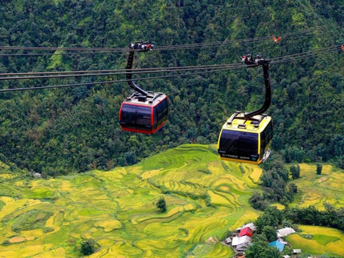
Summit temple complex and cable car constructed
Stone pagoda and statue complex built without consultation of local H’mong communities. The Sun World cable car opens in 2016, reducing the ascent to 30 minutes. Monthly visitors reach tens of thousands.
Two mountains on one peak
The trekking route (2–3 days full, 1 day via Tram Ton) continues alongside cable car tourism. The two experiences share a summit but almost nothing else.
The Summit Then and Now
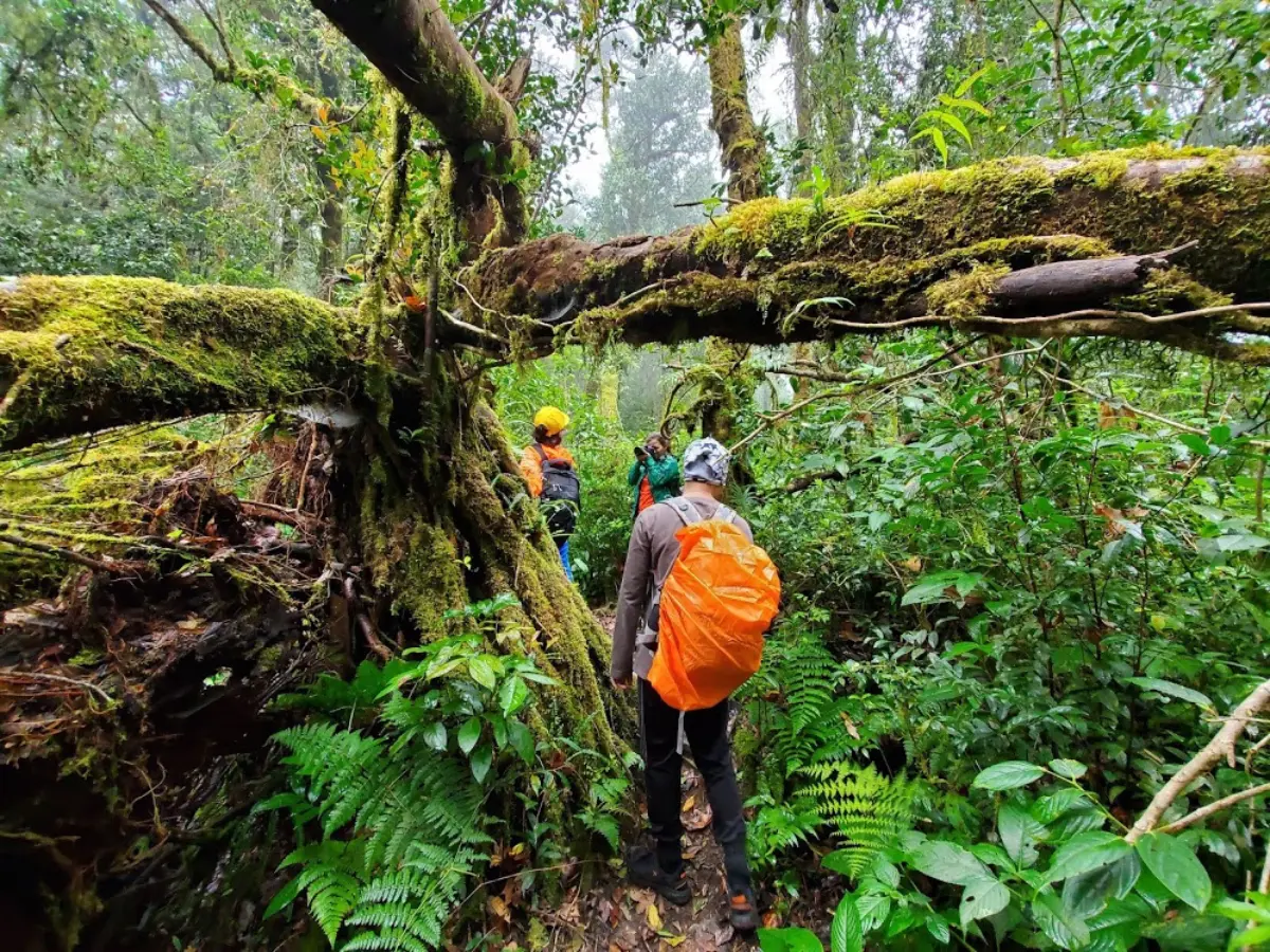
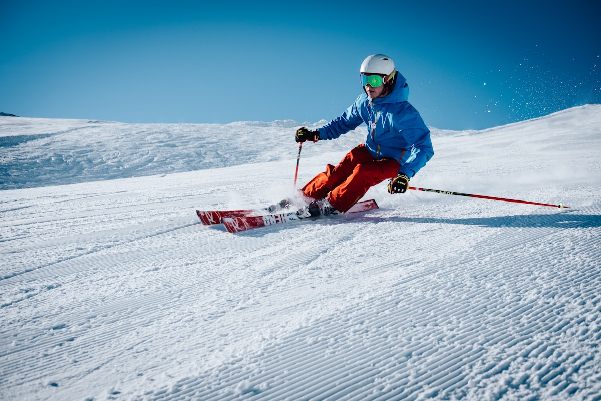
Until the late 1990s, Fansipan was a serious mountaineering objective. The approach routes through dense rhododendron and bamboo forest required navigation skills, camping equipment, and several days of genuine physical effort. The routes were not maintained. There were no huts. Getting to the summit and back was an undertaking that selected for a particular kind of traveler.
The trekking route that opened to mass tourism in the 2000s changed this. The path from Tram Ton Pass — on the Sapa–Lai Chau road at 1,900m — became the standard approach. It is still a serious climb: approximately 9 km one way, gaining 1,247m of elevation, requiring 6–8 hours upward in good conditions. But it is a maintained trail with waymarking, and it can be completed in a single day with an early start.
In 2016, the Sun World cable car opened from Cat Cat Village to the summit area. The ride takes approximately 30 minutes. From the cable car terminus, a 600-step staircase leads to the summit marker at 3,147m. The experience is accessible to anyone who can manage stairs. Monthly visitor numbers went from hundreds to tens of thousands.
The Fansipan Summit stone church, Buddhist pagoda, and statue complex were constructed between 2010 and 2016. This construction was not preceded by consultation with the Black H’mong communities living below. For a community that regards the summit zone as spiritually significant — as territory belonging to neeb, not to human infrastructure — the installation of permanent religious structures from a different tradition on that terrain was not a neutral act. The reaction in Lao Chai and Ta Van villages was not uniform, but the absence of consultation was widely noted.
Why the Trekking Route Still Matters
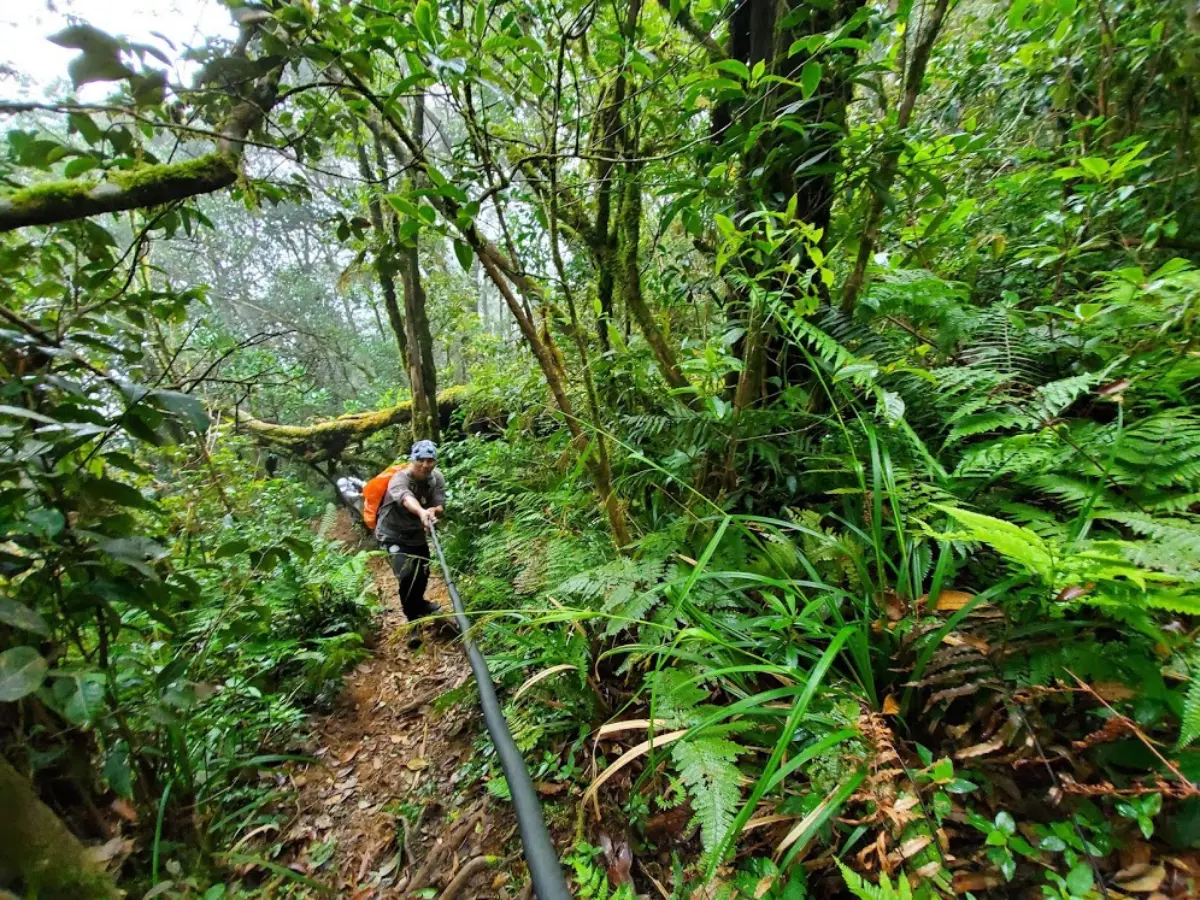
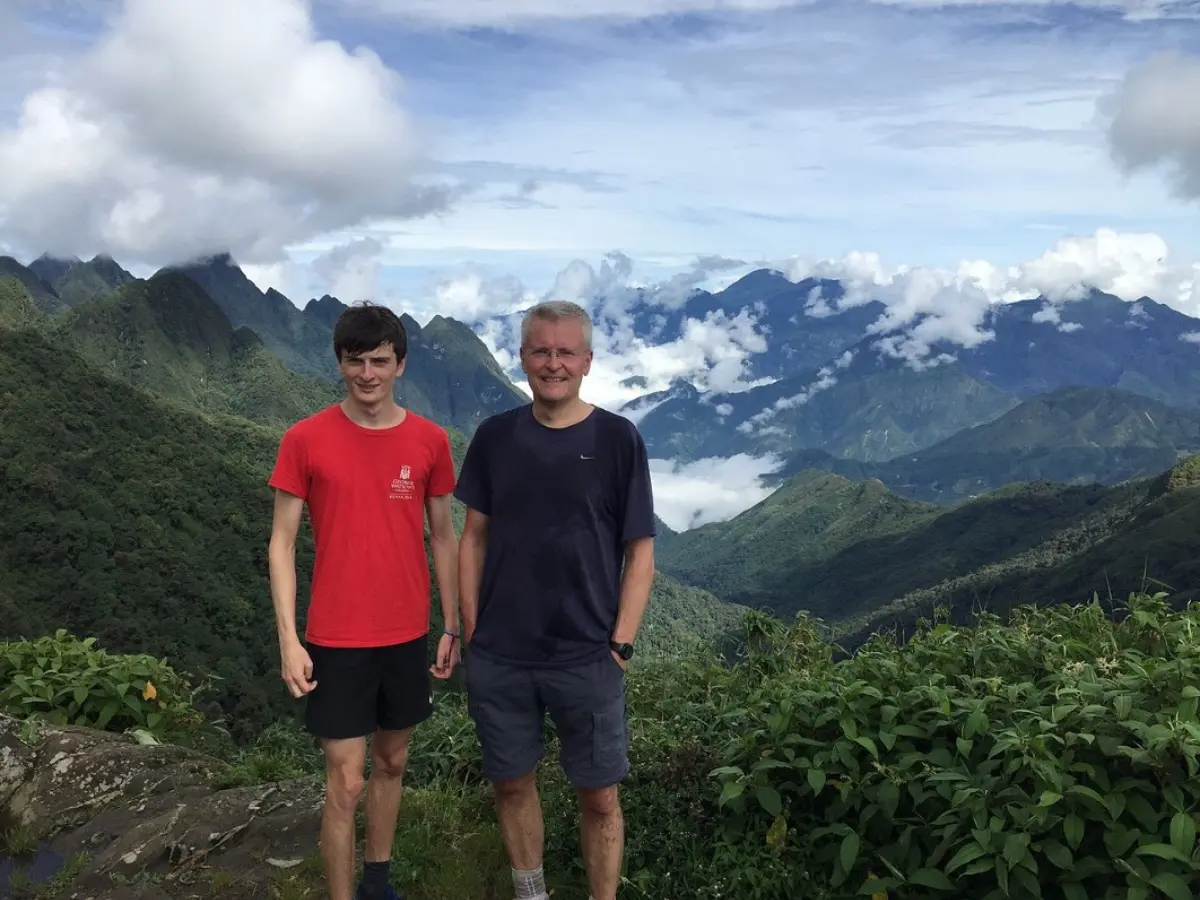
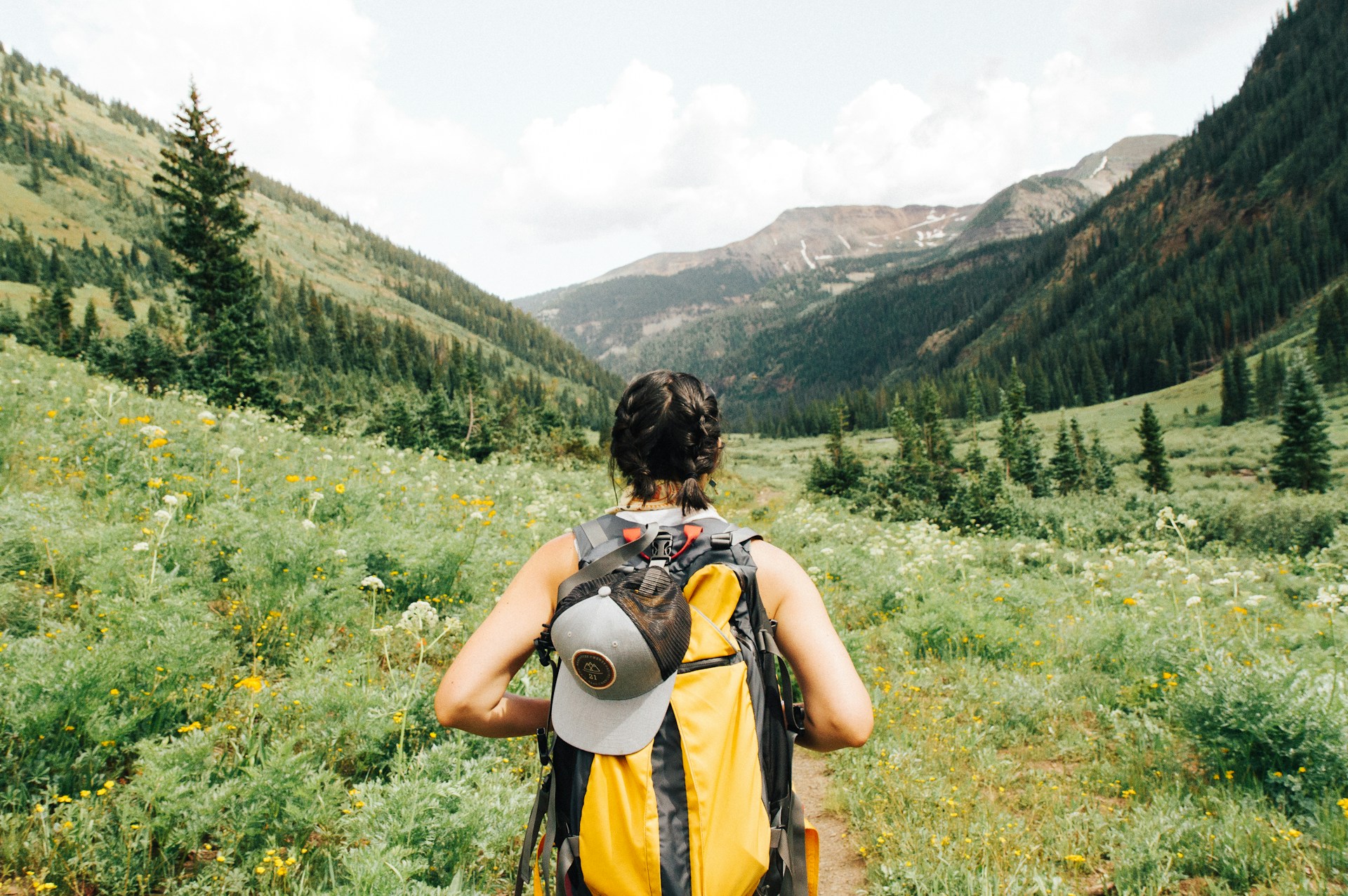
The 1-day Fansipan trek from the Tram Ton trailhead at 1,900m gains approximately 1,247m of elevation over about 9 km / 5.6 miles. This is not a gentle walk. By the second hour, the trail has left the bamboo zone and entered the transition scrub — shorter vegetation, more exposed ridgelines, and the first sense of genuine altitude.
Between 2,200m and 2,600m, the terrain shifts from bamboo forest to rhododendron-dominated subalpine scrub. This zone has the highest density of endemic plant species in Vietnam — flora that exists nowhere else on earth and is completely invisible to anyone who takes the cable car. The rhododendrons bloom white and red from January to March. Walking through them in that season, with frost still on the ground at 7am and the summit appearing and disappearing in cloud above you, is an experience with no cable car equivalent.
Above 2,800m, the terrain opens to rocky outcrops and dwarf scrub — this is the Fansipan the H’mong elders described. The air is noticeably thinner. The temperature can drop 8–10 degrees in an hour as cloud rolls in. The trail below 2,200m crosses areas where H’mong families from Lao Chai and Ta Van traditionally gathered medicinal plants — sa shán (cardamom), various roots used in H’mong herbal medicine, and plants with Vietnamese names that most visitors will never learn.
Your guide on the Fansipan trekking route is not just a safety resource. They are, in many cases, walking their family’s historical terrain. Our local guides know every section of this trail by what grows along it at different times of year, by which sections turn to mud after rain, by the specific way the wind shifts when cloud is building from the southwest. That knowledge comes from a lifetime on this mountain, not from a guide certification course.
The descent from the Fansipan trekking route passes through rhododendron forest in bloom from January to March — white and red flowers at 2,800–3,100m. This is the season the mountain looks most like what the H’mong elders described: remote, quiet, and genuinely difficult. Visitor numbers on the trekking route are also lowest in this period.
Planning Your Fansipan Trek
The best season for Fansipan is October through December. Skies are clearest, temperatures at the summit range from 5–15°C, and the post-harvest light in the Muong Hoa Valley below makes the approach from Sapa worth leaving before dawn to see. January and February are colder — frost and ice are possible at the summit — but the rhododendrons make it worthwhile for those prepared for the cold.
The worst season is July and August. Heavy monsoon rain turns the trekking trail into deep mud above 2,200m. The summit is in cloud most of the time. Even experienced trekkers have difficult days on the route in peak monsoon. If you are visiting Vietnam in July or August and want to see Fansipan, the cable car is the honest recommendation — you will not regret it less on the trail in those conditions.
- 1-Day Fansipan Trek: 9 km up from Tram Ton trailhead, cable car descent. Start at 7am, summit by early afternoon, cable car down by 3pm. Full summit day with a local guide who knows the route.
- Full 2-Day Fansipan Trek: Overnight at a mountain hut at approximately 2,800m, summit at sunrise. The experience that existed before mass tourism changed the mountain. Requires fitness preparation.
- Cable car + summit visit: 30-minute ride, 600-step staircase. No guide required. Appropriate for families, travelers with limited mobility, or anyone who wants the views without the climb.
What to bring (mandatory above 2,500m in any season): full waterproof jacket and trousers, trekking poles, headlamp for pre-dawn starts, warm mid-layer, at least 1.5 litres of water, snacks for 8+ hours. The summit can be 15 degrees colder than Sapa Town. This is not a mountain where you improvise gear.
The Fansipan Routes We Lead
 Difficult
Fansipan Trek One Day Tour
Tram Ton trailhead at 7am, cable car descent — full summit day with a local guide who knows every ridge.
 Difficult
Mount Fansipan 2 Days Trek
Overnight at 2,800m. Summit at sunrise in clear conditions — the way the mountain was meant to be climbed.
 Easy
Easy
Rice Fields and Fansipan Experience
See both — rice terrace valleys in the morning, Fansipan summit by cable car in the afternoon.
Fansipan Requires the Right Gear — Rent at Our Office
 Gear Rental
$2/Day
Gear Rental
$2/Day
Trekking Boots Rental
Waterproof ankle-support boots. Cleaned and checked before each rental. Available at 105 Thach Son Street.
 Gear Rental
$2/Day
Gear Rental
$2/Day
Walking Poles Rental
Trekking poles available to rent at $2/day at our office, 105 Thach Son Street. Essential for descents.
Frequently Asked Questions
The name derives from H’mong language — roughly “the great rocky peak” or “giant stone mountain.” The official Vietnamese spelling is Phan Xi Păng. “Phan Xi” comes from H’mong words meaning large or giant, and “Păng” refers to a rocky surface or rocky prominence. Different H’mong dialect groups pronounce it slightly differently; the standard Vietnamese romanisation has stabilised around “Fansipan” in international usage.
The first recorded Western ascent was made by M. Vignie of the French colonial service on June 6, 1905, with a party that included local guides (unnamed in the colonial record). Local H’mong communities almost certainly reached the summit before that date — the 1905 ascent was the first documented by European sources, not the first ascent by any person.
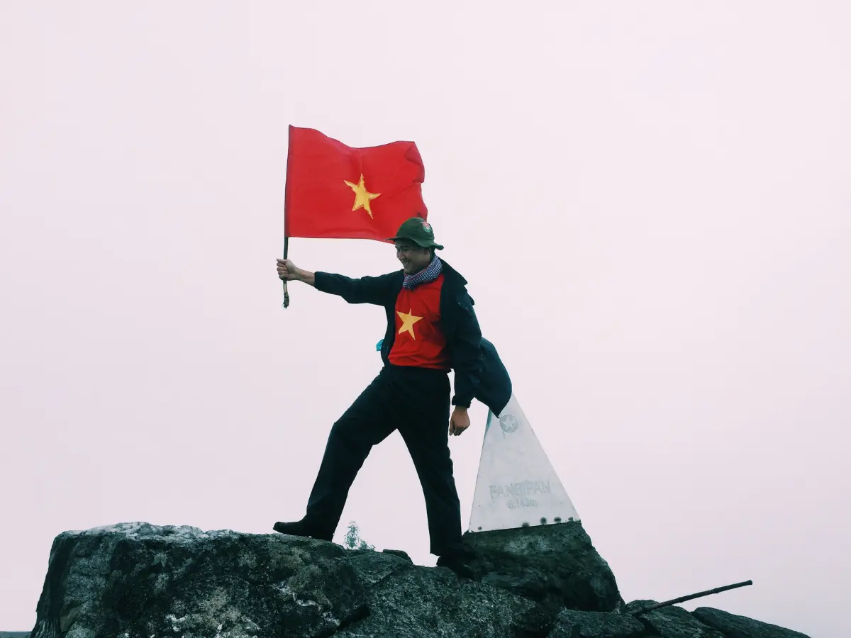
The summit has a metal plaque marking 3,147m, a stone staircase and pagoda complex built in 2010–2016, a small Buddhist statue, and a Vietnamese flag. The cable car terminus is about 200m below the summit, connected by a 600-step staircase.
The cable car takes 30 minutes and costs about 800,000–900,000 VND ($32–36). The trekking route takes 6–8 hours upward and requires a licensed local guide. Trekking gives you the mountain itself — the forest, the subalpine zone, the genuine altitude experience. The cable car gives you the views without the effort. Both are valid depending on what you want from the day.
Temperatures at 3,147m are typically 5–15°C in October–December, dropping to 0–5°C in January–February when frost and ice are possible. In June–August the temperature is milder (10–18°C) but rainfall is heavy. Always bring a full waterproof jacket regardless of season — the summit can shift from sunshine to freezing mist in under an hour.
Yes. High mountains in H’mong cosmology are associated with spirit presences and have practical significance as weather indicators and seasonal markers. The construction of the cable car and summit temple complex was not welcomed by all local H’mong communities. The trekking route below the cable car zone crosses terrain that has historical and spiritual significance for the Lao Chai and Ta Van villages.