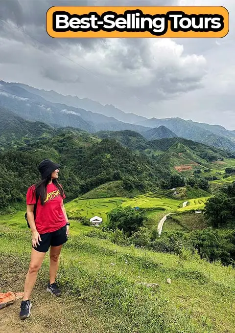
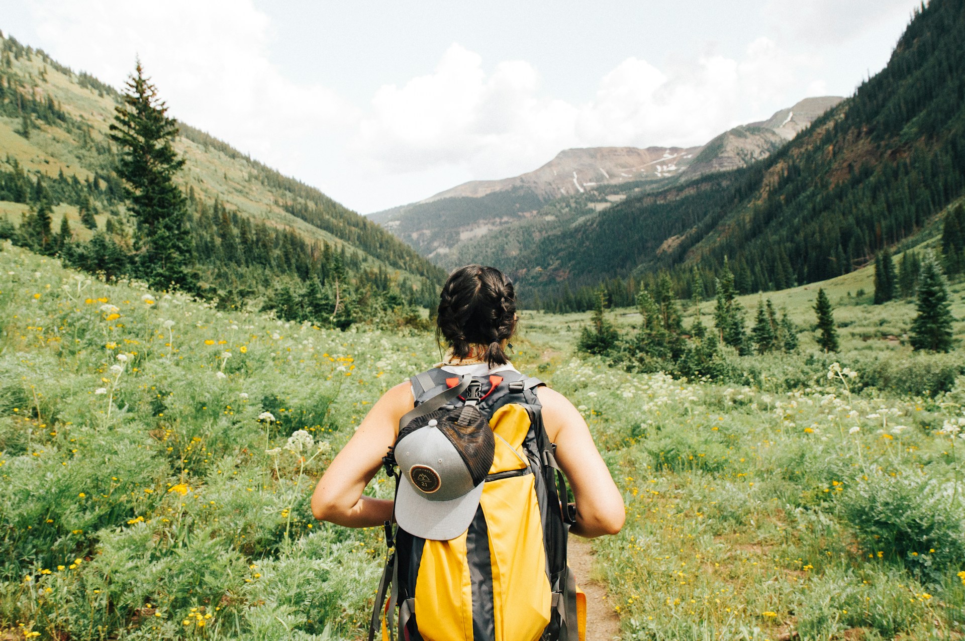
The alarm went off at 4:45am. I was in a thin-walled guesthouse in Dong Van, and the single wool blanket had done its best against the October cold coming off the Dong Van Karst Plateau. I didn't care. I'd been on this road a hundred times and I was still awake before the alarm — because the sunrise light on the limestone cliffs at that hour is something I cannot stay in bed for.
People ride the Ha Giang Loop for a lot of reasons: the freedom, the altitude, the quiet that comes from being deep in northern Vietnam's most isolated province. But nearly everyone arrives home with the same problem. They have hundreds of photographs they love. And they have no idea what to write underneath them.
I've put this list together from conversations with travelers I've sent north over the years. I work primarily with Sapa trekking groups, but Ha Giang is the other mountain destination I recommend without hesitation. The captions below are organised by mood and by location — scroll to what fits your photo and copy freely. I've written them as if I were posting myself, because that's the only way these things feel real.
Landscape
Mã Pí Lèng pass, rice terraces, river bends — focus on scale and light
Culture
Hmong women in markets, children playing, elderly faces — respectful, context-rich
Food
Thắng cố, corn wine, street corn — show preparation and texture, not just plating
Adventure
Bike POV shots, winding road curves, clouds below — motion and scale
Emotional
Quiet moment at dusk, tired but smiling, hands on handlebars — the feeling, not the view
Golden hour
6:00–7:30am and 4:30–6:00pm — rice terraces glow, mist fills valleys
Before You Post: What Makes a Ha Giang Caption Actually Work
The best caption for a Ha Giang Loop photo names something specific — a colour, a time, a place name — rather than a feeling everyone claims to have had. "Changed my life" tells your followers nothing. "The Nho Que River is the same turquoise as a swimming pool but the canyon walls on either side are 200 metres tall and completely silent" — that tells them something they didn't know.
A few things I've noticed about captions that actually get saved and shared by people who have been to Vietnam or want to go:
- Name the place precisely. "Vietnam" is too vague. "Ma Pi Leng Pass" signals that you actually rode the full loop, not just the highway.
- Give the time of day. "5:30am on the Dong Van plateau" is specific. It tells readers something about effort and light.
- Include one honest detail. The road has sections that will make you nervous. The homestays are basic. The cold in October is real. Honesty creates trust.
- Hashtags in a comment, not the caption. The caption itself should read like a thought, not a keyword list.
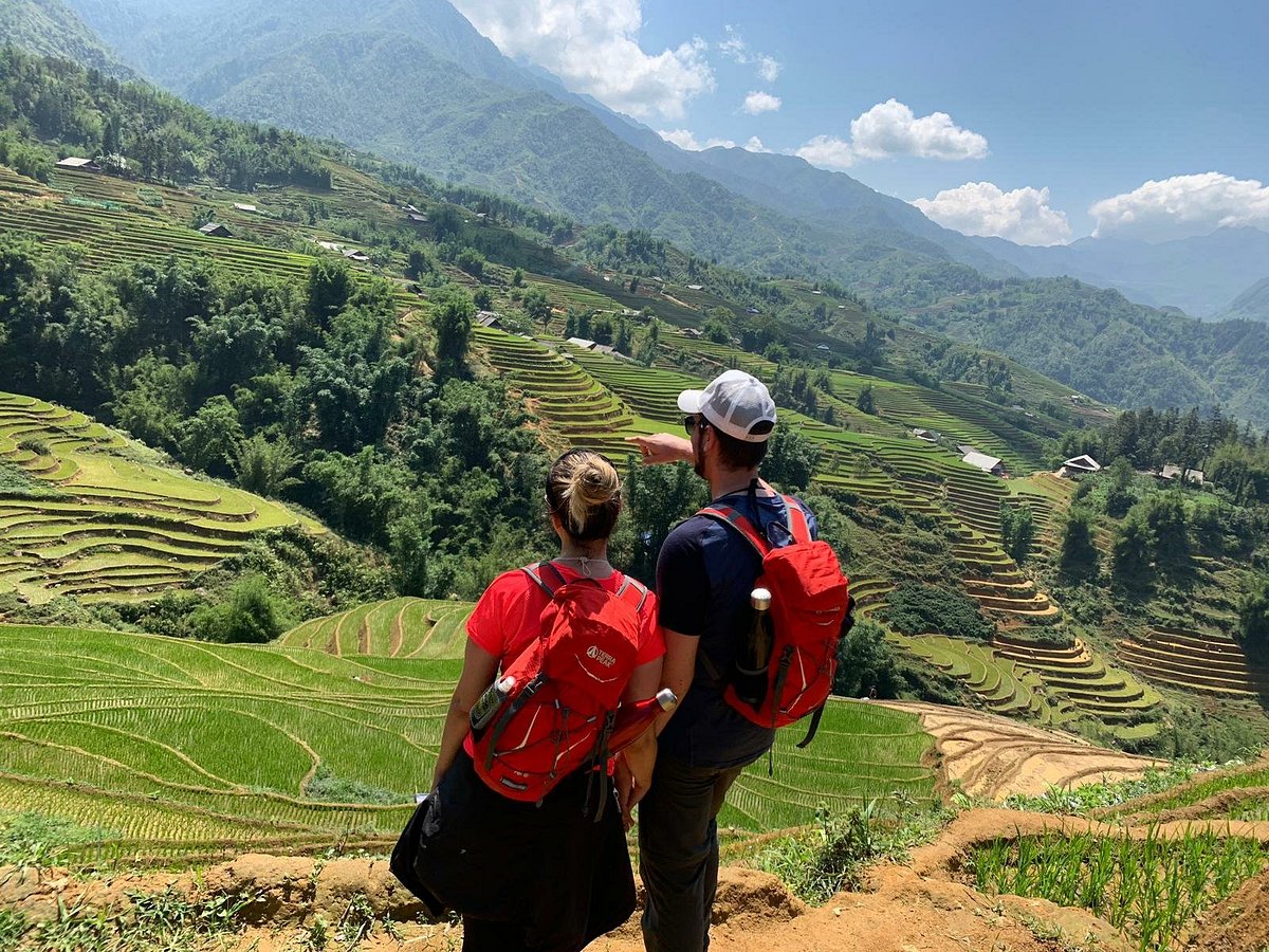
Rule of thirds works especially well on the winding road shots at Ma Pi Leng — put the road entering from the lower-left corner and let the canyon fill the upper right. For the Hoang Su Phi terraces, include one human figure or one water buffalo in the frame for scale. Without a reference point, the terraces read flat on a phone screen.
Ma Pi Leng Pass and Nho Que River Captions
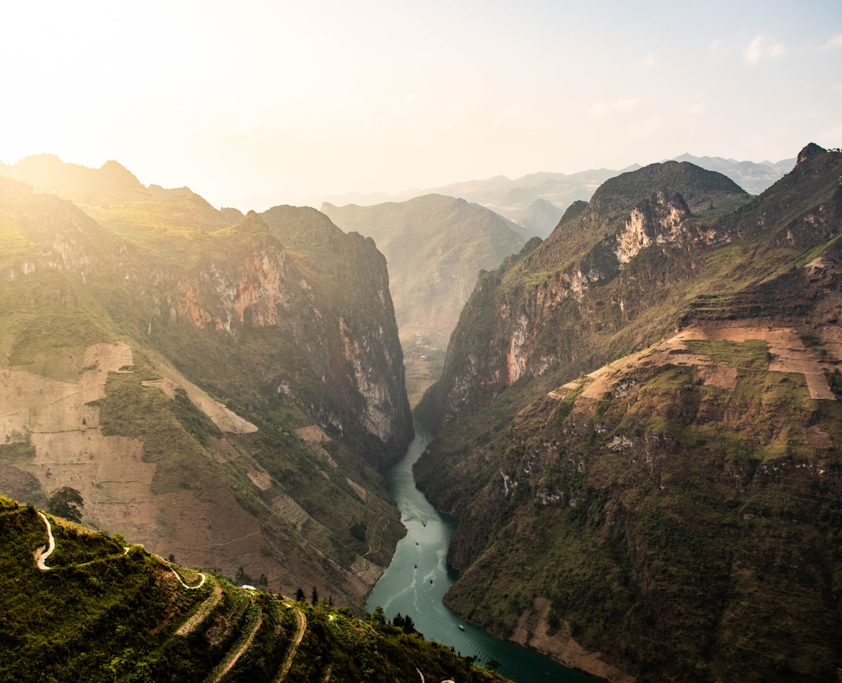
Ma Pi Leng Pass — the section of road between Dong Van and Meo Vac that took hundreds of workers three years to chisel through limestone — produces the most shared photographs from the entire Ha Giang Loop. The Nho Que River is the element that makes these shots distinctive: it runs turquoise green through the canyon below, completely at odds with the grey-brown rock on both sides.
I stop at three viewpoints here when I'm with a group. The first is at the highest point of the pass where the road bends sharply left — you can see the full canyon from above. The second is 2 km further towards Meo Vac, where there's a small concrete railing and the road curves into view in both directions. The third is down near the river, where a narrow footpath leads to the water's edge at a spot locals call the Nho Que boat landing — the colour of the water is clearest here before 9am.
- "The road took three years to build. The canyon took 250 million years. I was here for forty-five minutes and I don't think I've recovered yet. — Ma Pi Leng Pass, Ha Giang"
- "Someone carved a road through a mountain range and then painted the river at the bottom the colour of a swimming pool. This is actually what it looks like. No filter. — Nho Que River, Ha Giang Loop"
- "200 metres straight down and the water is still that colour. Vietnam does things to your sense of scale. — Ma Pi Leng Canyon"
- "My hands were cold from the altitude. I stopped here anyway. Some views demand that you stop. — Ma Pi Leng Pass, elevation 1,500m"
- "I've driven through mountain passes in four countries and this is the only one where I actually pulled over and sat with it for a while. — Ha Giang Loop, northern Vietnam"
- "The road bends, the canyon opens, and then there's this river the colour of jade far below. I wasn't prepared for it even though I knew it was coming. — Dong Van to Meo Vac section"
- "The road. The river. The canyon. No filter needed. #MaPiLeng"
- "Left Dong Van at 5am. Found this. Worth every kilometre."
- "Ha Giang Loop. Day 3. Still not used to it."
- "The Nho Que River from above. October. Perfect light."
- "Carved through limestone. This road should not exist. But it does."
Hoang Su Phi Rice Terraces — September and October Harvest Captions
Hoang Su Phi is where the photographs from the Ha Giang Loop get compared most often to Sapa — and it's a fair comparison. The rice terraces here belong primarily to the La Chi and Dao ethnic minority communities, and the harvest season in late September through mid-October turns the entire hillside gold. I tell everyone I send up there: if you can only be in northern Vietnam for one specific week, make it the last week of September. The Hoang Su Phi terraces at that time look like something that was composed for a painting.
The best shots come from the hillside above the village of Nam Hong, where you can get three layers of terraces in the same frame with the village rooftops in the mid-ground. Early morning fog settles in the valleys between the terraces and burns off around 9am — if you arrive at 7am you get both the mist and the gold in one shot.
- "The rice turns gold the last week of September. I planned my entire trip around this one week. Standing here at 7am with fog in the valley below, I think that was the right decision. — Hoang Su Phi, Ha Giang"
- "Layers of terraces cut into a hillside by La Chi families over hundreds of years. From above, the whole mountain looks like it's been hammered into steps by hand. Because it was. — Hoang Su Phi rice terraces, October"
- "Everything is yellow-gold and the fog is still sitting in the valleys between the tiers. This is the light that travel photographers come back to northern Vietnam for. — Nam Hong village area, Hoang Su Phi"
- "The harvest takes three weeks. Families work from first light. The sound is of sickles and water running between terraces. I didn't take a photo for the first ten minutes — I just listened. — Hoang Su Phi, Ha Giang Province"
- "I added one extra day to the loop specifically for Hoang Su Phi. If you skip it to save time, you will regret it. — September, Ha Giang Loop extended route"
- "Before the harvest, the terraces are fifty shades of green. Not the same photograph as October, but a completely different one. Both worth making the trip for. — Hoang Su Phi, July"
- "Flooded terraces in June reflect the sky. The whole hillside becomes a mirror. — La Chi community land, Hoang Su Phi"
- "Green, always green. July in the northern highlands means the paddies are full and the water is still. — Ha Giang Loop, rainy season"
The Hoang Su Phi rice harvest usually peaks between September 20 and October 10, but it shifts by a week depending on the year's rainfall. Check with a local operator around September 10 before booking your dates — the window is genuinely narrow and worth timing precisely.
Dong Van Karst Plateau and Sunrise Captions
The Dong Van Karst Plateau is a UNESCO Global Geopark — one of only four in Southeast Asia — and the landscape around Dong Van town is the most visually alien section of the entire loop. The limestone formations here are older than almost anything you'll see in Vietnam: some of the rock is 600 million years old. At sunrise, when the temperature is usually between 8 and 12 degrees Celsius in October, the light hits the grey-white karst formations at a very low angle and the whole plateau turns the colour of old bone.
Sunrise from above Dong Van town is at approximately 5:30am in October. You need to be on the hillside trail above the Sunday market area by 5:15am. It's a 15-minute walk up a stone path — do not use a motorbike for this, you'll make noise and disturb the households along the path. Bring a headlamp and one warm layer more than you think you need.
- "5:30am on the Dong Van Karst Plateau. The limestone is still cold from the night and the sun is coming over the eastern ridge. I've been here four times and it looks different every single morning. — Ha Giang Loop, day 2"
- "The rock is 600 million years old. I set an alarm for 5am to watch the sun hit it. That felt like the right trade. — Dong Van UNESCO Geopark, Ha Giang"
- "Woke up when it was still dark. Walked up a stone path with a headlamp. Found this. Ha Giang is for people who believe the photograph is worth the cold. — Dong Van Plateau, October"
- "The fog sits in the valleys between the karst formations until the sun burns it off. For about 20 minutes, the peaks float. — Dong Van, Ha Giang Province"
- "Every travel guide says 'worth waking up early for.' Most of the time they're wrong. This one is not. — Dong Van sunrise, 5:35am"
- "Quiet up here. The whole plateau to yourself and the birds. I understood in that moment why people come back to Ha Giang. — Dong Van Karst Plateau viewpoint"
- "Dong Van old quarter has French colonial buildings from the early 1900s sitting between H'mong and Chinese shop-houses. The architecture alone is worth two hours of wandering. — Dong Van, Ha Giang"
- "Sunday market in Dong Van: Flower H'mong, Black H'mong, and Lo Lo communities selling everything from hand-embroidered cloth to live chickens. I bought a belt. I didn't need a belt. — Dong Van Sunday market, Ha Giang"
- "The Meo Vac Saturday Market is the bigger one. But the Dong Van Sunday market is where the Lo Lo community comes down from the hills and it's quieter and less observed. Both are worth seeing. — Ha Giang Loop"
Lung Cu Flag Tower Captions
Lung Cu is Vietnam's northernmost point — the flag tower stands at the top of Dragon Mountain, and on a clear day you can see into Yunnan Province, China, from the viewing platform. It's a 200-step climb to the base of the tower after a motorbike ride up a switchback road. The road to Lung Cu from Dong Van passes through Lung Tam village, where you'll see the Black H'mong weaving cooperative that produces the hemp cloth used in traditional jackets and skirts — the indigo smell of the dye is sharp and cold in the morning air.
- "Vietnam's northernmost point. The flag up there is 54 square metres — one for each ethnic group in the country. Standing here, that number feels significant. — Lung Cu Flag Tower, Ha Giang"
- "200 steps up Dragon Mountain to reach the base of the tower. Behind me is Vietnam. Past the ridge in front of me is China. The line between countries is invisible from here. — Lung Cu, Ha Giang Province"
- "The road to Lung Cu passes through Lung Tam where the H'mong weaving cooperative has been working since before tourism existed in this area. Stop there. Don't rush the flag tower. — Ha Giang Loop day 2"
- "The top of Vietnam. I didn't expect to feel anything particular and then I stood there and the wind was very strong and the view went on forever and I did feel something. Not sure what. — Lung Cu, October"
- "You can see into China from here on a clear day. The border is a ridge line. The ridge line is indifferent to it. — Lung Cu Dragon Mountain summit"
Meo Vac Saturday Market — Cultural and Portrait Captions
The Meo Vac Saturday Market is the single most photographed cultural event on the Ha Giang Loop, and also the one that deserves the most careful approach. This is a real weekly trading market — Black H'mong, Flower H'mong, Red Dao, and Lo Lo families ride or walk in from villages that can be 2–3 hours away. They come to trade livestock, fabric, tools, and food. They come to see relatives. They do not come to be photographed.
I've seen travellers point cameras at people eating their breakfast without asking, and I've seen H'mong grandmothers turn away with real annoyance. If you want portraits that mean something, ask. A smile and raising the camera as a question is universally understood. Most people will agree, some won't, and both responses should be respected. The photographs where someone agreed and is looking back at you are worth ten times the grabbed shots from behind.
- "Meo Vac Saturday Market. The Flower H'mong walk down from villages 2–3 hours away for this. The embroidery on the sleeve of the woman who sold me these apricots took her three months. I asked. — Ha Giang Loop"
- "Red Dao, Black H'mong, Flower H'mong, Lo Lo. Four communities at the same market. The indigo dye smell of freshly made cloth is something I associate entirely with Saturday mornings in Meo Vac. — Ha Giang Province"
- "She agreed to this photograph. I showed it to her on the screen. She laughed and said something I didn't understand and walked away. That felt like the right ending. — Meo Vac market, Ha Giang"
- "The market opens before dawn. By the time the tourist minibuses arrive at 9am, the best trading is over and the light is high and flat. Arrive at 7am. Eat the corn cake from the woman by the entrance. — Meo Vac Saturday Market tip"
- "Northern Vietnam's ethnic minority communities dress in ways that took generations to develop. The Flower H'mong embroidery patterns carry clan identity. Photograph that history with respect or don't photograph it at all. — Meo Vac, Ha Giang"
Always ask permission before photographing anyone closely at Meo Vac or any ethnic minority market. Never photograph people eating or in private moments without asking. If someone declines, lower your camera immediately. The markets exist for the communities who attend them — not for our photography. This is not a rule, it's basic respect for the people whose home you are visiting.
Adventure and Motorbike Captions for the Open Road
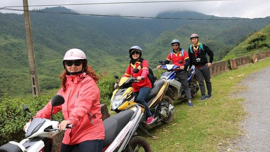
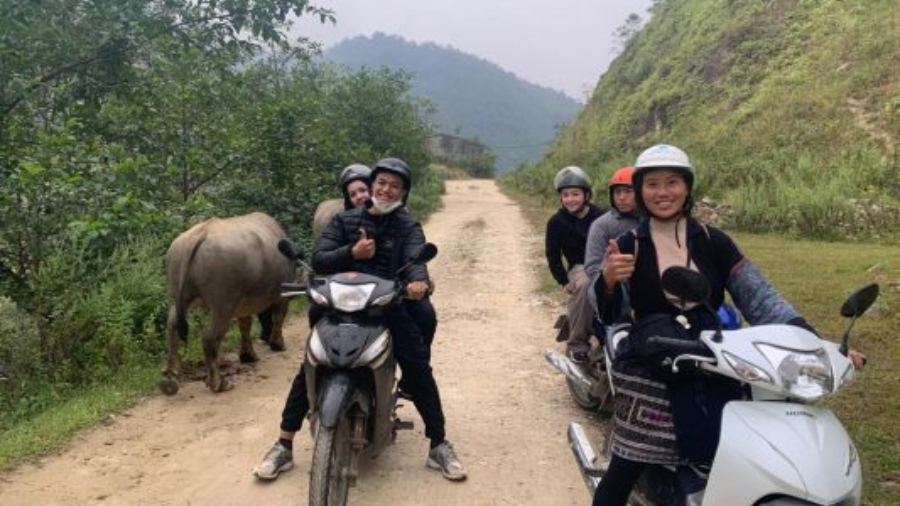
Some of the best photographs from the Ha Giang Loop are the simplest: the road ahead, the motorbike parked at a viewpoint, the rider small against the mountain scale. These shots work because the Ha Giang Loop road itself is genuinely one of the most dramatic pieces of engineered infrastructure in Southeast Asia — it was built by hand through solid limestone, largely by ethnic minority workers, over several decades. The road is the subject.
- "350 km. Four days. No signal for most of it. The Ha Giang Loop is the best reason I know of to turn your phone off. — Ha Giang Province, northern Vietnam"
- "The road goes up, then it goes further up, then it bends back on itself and goes up again. I was not prepared for how physical this loop is on a semi-automatic motorbike. I was also not prepared for how good it feels. — Ha Giang Loop day 1"
- "There are Easy Rider guides who will take you through the loop on the back of their motorbike. If you're not experienced on mountain switchbacks, use one. Your photographs will be better — you're not watching the road, you're watching the scenery. — Ha Giang Loop advice"
- "The pass looks different depending on which direction you ride. Meo Vac to Dong Van: you're climbing into the clouds. Dong Van to Meo Vac: you're descending into the canyon. Both are worth doing if you have time. — Ma Pi Leng Pass"
- "I parked here and sat on the barrier for twenty minutes. Not taking photos. Just being in it. — Ha Giang Loop, somewhere between Quan Ba and Yen Minh"
- "The Queen's Palace viewpoint at Quan Ba on day one. Two round hills in a valley — the local name translates as the Fairy Bosom. I didn't write that caption but I thought about it. — Quan Ba, Ha Giang"
- "Seven switchbacks visible from this point. The road down to the valley took 40 minutes. Worth every turn. — Ha Giang Loop"
Self-Discovery and Reflective Captions
The Ha Giang Loop produces this kind of caption more than almost any other travel route I know, and it's not manufactured sentiment — there is something about riding through that much isolation, that much scale, with that little phone signal, that actually does change the way a lot of people think for a few days. These captions lean into that without overclaiming.
- "I rode into this valley with no wifi and no plan and the only thing that happened was that I felt better. Ha Giang has that effect. — Ha Giang Loop, northern Vietnam"
- "There are places where the scale of the landscape makes your own concerns feel appropriately small. This is one of those places. — Dong Van Karst Plateau"
- "I don't know if I found myself on this trip. But I found some very good coffee in Dong Van and a road I'll be thinking about for years. — Ha Giang Loop, day 3"
- "I came here to get away from noise. Ha Giang is the least noisy place I've found in Vietnam. That's not a small thing. — Ha Giang Province"
- "The H'mong families along this road have been here for centuries. The road itself is 60 years old. I've been here three days and the whole arrangement makes me feel like a very recent arrival, which I am. — Ha Giang Loop"
- "Some places make you want to come back before you've left. — Meo Vac, Ha Giang"
- "I had a list of things to think about when I got home. On day two of the loop, I couldn't remember what they were. On day four I still couldn't. That's the best thing this road did for me. — Ha Giang Loop"
- "The guesthouse mattress was thin and the blanket was thinner and the shower was cold. I slept better than I have in months. — Dong Van homestay, Ha Giang Loop"
- "The road to Lung Cu had a section of loose gravel after the rain. I went slow. The views got better as I got more careful. There's probably a lesson there. — Ha Giang Loop, October"
- "I was nervous on the Meo Vac descent. Not 'exciting nervous' — properly nervous. I took it at 15 km/h and pulled over twice. The canyon below was still there when I reached the bottom. — Ma Pi Leng descent"
- "Day 4 back into Ha Giang city. Hot shower, cold beer, a bed with a real pillow. And already I want to go back. — Ha Giang Loop completed"
Ha Giang Loop Photography Tips: Getting the Shot
The most consistent piece of advice I give to photographers heading to Ha Giang is to leave the viewpoints before the tourist minibuses arrive. At Ma Pi Leng, that means being in position by 5:30am. At Hoang Su Phi, by 7am. By 9am at most major stops, the light is high and hard and the best shots are already behind you for the day.
The Easy Rider guides who operate on the loop are an underused photography resource. The ones who have been running this route for years know exactly where the best angles are — they stop at pull-outs that don't appear on any map and that most solo riders drive straight past because they're concentrating on the road. When I take photography-focused groups to Sapa, I always tell them: the local guide does not just know the history, they know where the light is good at what time of day. The same is true for Ha Giang.
Using Leading Lines
The Ha Giang Loop road is one of the best natural leading lines in Vietnam. Use the road itself to pull the viewer's eye into the frame — enter from the lower third and let it curve upward. The switchback sections near Dong Van work particularly well from above, where you can get four or five curves of road in the same vertical frame.
Scale and Human Reference Points
Without a person or an object of known size, the scale of the Dong Van Karst Plateau reads as flat on a phone screen. Place yourself, your motorbike, or ideally a local person walking the road in the frame. The size difference between the human figure and the limestone walls behind does the work that no filter can replicate.
The Colour of the Nho Que River
The turquoise-green colour of the Nho Que River is real and does not require enhancement in post-processing. It comes from the mineral content dissolved as the river flows through the limestone. The colour is strongest in the morning before 9am when the sun hits the canyon at a low angle from the east. By midday the water reads blue-grey. If you're posting the turquoise shot and someone asks if it's edited, the answer is no — that is actually what the water looks like.
The Nho Que River's turquoise colour is real — don't oversaturate it in editing or it looks fake. Pull the highlights down slightly on the canyon walls to keep detail in the rock, and the river colour will stand on its own. The same principle applies to the gold of the Hoang Su Phi harvest: the colour is there, it just needs the exposure right.
Ha Giang Loop vs. Sapa: Where to Go and What to Post
I get this question from travelers who have limited time and want to choose between the two. The honest answer is that they offer different things, and the photographs reflect that difference.
Sapa — which is where our team at Trekking Tour Sapa operates — is more accessible, more developed, and offers the best rice terrace trekking in northern Vietnam. The Muong Hoa Valley with Black H'mong villages like Lao Chai, Ta Van, and Y Linh Ho is trekking and culture. The Sapa photographs are green valleys, village life, and trails through terraces. If you want to actually walk through the landscape, Sapa is the right answer.
Ha Giang is more remote, more physically demanding, and requires either motorbike experience or willingness to trust an Easy Rider guide. The photographs from Ha Giang are dramatic geology, long roads, and minority market culture. If you want the canyon and the scale, Ha Giang is the right answer.
Many travelers do both in the same trip: fly into Hanoi, take the overnight bus to Ha Giang, do the loop over four to five days, return to Hanoi, then take the overnight train or bus to Sapa for two to three days of trekking before flying home. If you're doing that combination, message us on WhatsApp — we can recommend operators in Ha Giang that we trust, and handle your Sapa trekking directly.
The Trekking Through Rice Terraced Fields tour in Sapa offers the kind of close cultural immersion with Black H'mong families that complements the Ha Giang Loop experience well — one destination for landscape scale, the other for village-level connection. Many of our repeat guests now do both in the same Vietnam visit.
Hashtag Strategy for Ha Giang Loop Posts
Post your hashtags in the first comment on Instagram rather than the caption itself. This keeps the caption readable and the algorithm still indexes the hashtags. A mix that works well for Ha Giang Loop posts:
- Location specific: #HaGiang #HaGiangLoop #MaPiLeng #DongVan #HoangSuPhi #NhoQueRiver #LungCu #MeoVac
- Country level: #Vietnam #NorthernVietnam #VisitVietnam #VietnamTravel
- Content type: #MotorbikeTravel #RiceTerraces #MountainRoad #EthnicMinority #SoutheastAsia
- Photography: #LandscapePhotography #TravelPhotography #GoldenHour
Avoid loading every Ha Giang post with identical hashtags — vary the selection based on what the specific photograph shows. A portrait from Meo Vac market should include #FlowerHmong and #TraditionalCulture rather than #MotorbikeTravel. A road shot at Ma Pi Leng should lead with #MaPiLeng and drop the cultural hashtags.
How to Write a Great Ha Giang Caption in 4 Steps
The formula is simple. Most captions that get saved and shared follow the same pattern — and it takes about two minutes once you know it.
Start with a specific detail, not a statement
Instead of "What an amazing view", write: "The road dropped 800 metres in 4 kilometres and my hands were shaking." Specific always beats general.
Add one sensory detail
Smell, sound, temperature, taste. "The corn wine tasted like liquid smoke and made my eyes water." Sensory details get saved.
End with a question or invitation
Comments = algorithm boost. "Have you ridden this road?" or "Tag someone who needs to see this." Simple, not pushy.
Hashtags: 5 targeted, not 30 random
#HaGiangLoop #MotorbikeVietnam #NorthernVietnam plus 2 niche tags for your specific photo subject. More than 10 looks desperate.
Trekking Sapa? Gear Up Before Your Trip
 Gear Rental
$2/Day
Gear Rental
$2/Day
Trekking Boots Rental
Waterproof ankle-support boots. Cleaned and checked before each rental. Available at 105 Thach Son Street.
 Gear Rental
$2/Day
Gear Rental
$2/Day
Walking Poles Rental
Trekking poles available to rent at $2/day at our office, 105 Thach Son Street. Essential for descents.
Frequently Asked Questions
September and October are the best months for photography on the Ha Giang Loop. The Hoang Su Phi rice terraces turn gold during harvest season, usually peaking in late September to mid-October. The light is softer, the air clearer, and the roads less crowded than summer. If you want green layered terraces instead of gold, June and July work well. Avoid January and February when fog can sit all day on Ma Pi Leng Pass and block the Nho Que River view entirely.
The most photographed viewpoint is on the main road at the highest section of Ma Pi Leng Pass, roughly at the point where a metal railing juts out over the cliff edge. You can see the turquoise Nho Que River cutting through the canyon far below, with the road winding back towards Meo Vac on the right side of the frame. Arrive by 5:30am for sunrise light hitting the canyon walls from the east — by 8am the sun is overhead and the river loses its turquoise colour. There is a small tea stall at the viewpoint run by a Black H'mong family where you can wait and warm up.
Technically, Vietnam requires a Vietnamese driving licence for motorbikes above 50cc, and the Ha Giang Loop roads typically require 110cc–150cc bikes to handle the climbs. In practice, foreign tourists rent semi-automatic bikes without a local licence routinely. However, if you are not experienced on mountain roads, the safer option is hiring an Easy Rider guide — a local experienced driver who takes you on the back of their motorbike. This removes the legal risk, keeps you safe on the steep switchbacks, and also means your guide knows where to stop for the best photographs.
The standard Ha Giang Loop is approximately 350 km and most people do it in 4 days and 3 nights. A common route is: Day 1 Ha Giang city to Quan Ba (Queen's Palace viewpoint), Day 2 Quan Ba to Dong Van (pass the Dong Van Karst Plateau UNESCO Geopark), Day 3 Dong Van to Meo Vac via Ma Pi Leng Pass, Day 4 Meo Vac back to Ha Giang city via Hoang Su Phi. If you have 5 days, use the extra day at Hoang Su Phi during rice harvest season — it is worth it.
Dress conservatively — long trousers and a top that covers your shoulders. The Meo Vac Saturday Market is a real weekly trading market for Black H'mong, Flower H'mong, Red Dao, and Lo Lo communities, not a tourist attraction. People come to sell, buy, and meet family. Always ask permission before photographing someone closely — a smile and holding up your camera as a question is universally understood. Never photograph people eating or in moments of private conversation without asking. If someone waves your camera away, respect it immediately.
Yes, the Ha Giang Loop is generally considered safe for solo female travellers. The main concerns are road safety — not crime. The switchbacks at Ma Pi Leng and the steep descent into Meo Vac are genuinely challenging even for experienced riders. Solo women who are not confident on mountain roads regularly hire Easy Rider guides and report feeling completely safe. Homestays along the route are family-run, basic but welcoming. The main risk is road conditions after rain — the road to Lung Cu Flag Tower can become muddy and slippery, and a few sections near Dong Van have loose gravel on corners. Ride slowly, never at night.