The first thing I want to say is that people die on the Ha Giang Loop. I am not going to soften that, because the travelers who read this honestly are exactly the ones who will make smart choices. The road from Ha Giang City through Quan Ba, Yen Minh, Dong Van, across Ma Pi Leng Pass to Meo Vac Town and back — roughly 350 km / 217 miles of mountain riding — is one of the most spectacular routes in Southeast Asia and also one of the most genuinely dangerous. Both of those things are true at the same time.
I work in Sapa, not Ha Giang, so I see northern Vietnam's mountain roads from the perspective of someone who lives and guides in this region. When guests finish their Sapa trek and ask me "should we do the Ha Giang Loop next?", I never tell them not to go. I tell them to go with their eyes open. This article is what I tell them.
How Many People Die on the Ha Giang Loop Each Year?
The honest answer is that no official annual death toll for foreign tourists on the Ha Giang Loop is published by Vietnamese authorities, and the number that circulates online — 10 to 20 foreign tourist fatalities per year — is an estimate pieced together from local operator accounts, Vietnamese news reports, and Facebook groups for Ha Giang travelers. It is not a figure you can verify through a government database.
What we do know from reported incidents: in 2017 a Spanish tourist died in a crash on Ma Pi Leng Pass. In 2018 a French woman and a Spanish man both lost their lives in separate accidents. In 2023 a British tourist fell from his bike near Pai Lung. These are just the cases that reached English-language news coverage — they represent a fraction of what actually happens across a full year, particularly when you factor in local Vietnamese riders.
To put the number in context: the Dong Van Karst Plateau Geopark area sees somewhere between 200,000 and 400,000 visitors per year depending on the season. The proportion who rent motorbikes and ride the full loop themselves is high — at peak season in October and November, the road from Dong Van to Meo Vac Town can feel genuinely busy with foreign self-riders. Even if the 10–20 figure is accurate, it represents a fatality rate that is meaningfully higher than popular motorbike routes in Thailand or Bali, because the consequences of a mistake at Ma Pi Leng Pass are not a gravel rash — they are a drop of several hundred metres.
Vietnamese traffic accident statistics do not separate "Ha Giang Loop" incidents as a distinct category. Local hospitals in Ha Giang City and Meo Vac Town see motorbike injury cases regularly during peak season — the medical staff there are experienced with road trauma from this route. If you are injured on the remote sections near Lung Cu Flag Tower or the Dong Van Karst Plateau, evacuation time to meaningful medical care is measured in hours, not minutes.
Do the Ha Giang Loop if…
Skip the Loop if…
The Accidents That Were Reported — What Actually Happened
Looking at the documented cases tells you more than any headline statistic. The patterns across reported accidents are consistent enough that they amount to a profile of how people die on this road.
The 2017 accident on Ma Pi Leng Pass involved a rider who lost control on the descent toward Meo Vac. The pass drops steeply from around 1,500 metres through a series of hairpin bends. There is no barrier for significant stretches. When a rider misjudges a corner — or their brakes overheat from constant use on a long descent — the margin for error is essentially zero.
The 2018 French woman fatality occurred on a section of road that was wet from overnight rain. This is a condition that veterans of the loop treat with extreme caution. The limestone rock of the Dong Van Karst Plateau becomes almost frictionless when wet — the road surface, even where it has been recently repaved, has a polished quality that catches out riders who carry too much speed into corners. A semi-automatic Honda Win with worn tyres on wet limestone is not a vehicle that gives you second chances.
The 2023 incident at Pai Lung involved a fall rather than a collision — a rider left the road at a section with a steep drop. The exact circumstances were not fully reported in English, but falls of this type typically happen in two scenarios: the rider brakes sharply to avoid something and loses front-wheel traction, or they are simply fatigued after a long day on the road and their reaction time has dropped.
The most recent widely reported case is from April 2026 — 19-year-old British tourist Orla Wates, travelling as a pillion passenger. Her story is told in full in the section below, because it is different in an important way from the others: she was not the rider, and it happened anyway. That distinction matters for anyone planning to travel the loop as a passenger rather than a driver.

April 2026: Orla Wates
The most recent case to reach international news is also the one that most clearly changes how you should think about this road — because Orla Wates was not a reckless rider. She was not even the driver. She was 19 years old, from London, on a gap year in South East Asia before she was due to start at Durham University. On 2 April 2026, she was riding as a pillion passenger on a motorcycle on the Ha Giang Loop. The driver lost control. She was thrown from the bike and struck by an oncoming truck. She was taken to Việt Đức University Hospital in Hà Nội, where she died from her injuries.

Her parents — father Andy Wates, a director of the Wates Group construction firm, and mother Henrietta — were in Vietnam when they faced what can only be described as an extraordinary moment of generosity. They agreed to donate Orla's organs. Her liver and both kidneys were successfully transplanted into three critically ill Vietnamese patients, saving their lives. It was the first time a foreign national had donated multiple organs in Vietnam. Dr Dương Đức Hùng, director of Việt Đức University Hospital, called it "a remarkably humanitarian decision — one that has given other patients a renewed chance at life."

"Orla was beautiful, independent and very funny, with a sharp wit. She loved to look good and lived life to the full. She had the best time here and she was loving every minute of it."— Henrietta Wates, Orla's mother
"Việt Nam was a country she loved — so to give back to Việt Nam is very important to us. From our perspective, absolutely what we wanted, and I know that's really what Orla wanted."— Andy Wates, Orla's father
Orla's story reached far beyond the Ha Giang backpacker community because of what it represented. She was not doing anything unusual — tens of thousands of young people ride the Ha Giang Loop as passengers every year. She was 19, curious about the world, on the kind of trip that shapes people for life. And her family, in the middle of unimaginable grief, turned that loss into something that let three other people continue living. Vietnam, a country Orla had come to love, received a gift from the people who loved her most.
I include this case not to suggest the Ha Giang Loop should not be ridden, but because it shows something the statistics alone cannot: the risk on this road is not limited to your own mistakes. When you choose to ride pillion, the question is not only about your own skill — it is about the driver's experience with mountain roads, their familiarity with the specific section, and whether the conditions that day are genuinely safe to ride. Those are questions worth asking before you get on the bike.
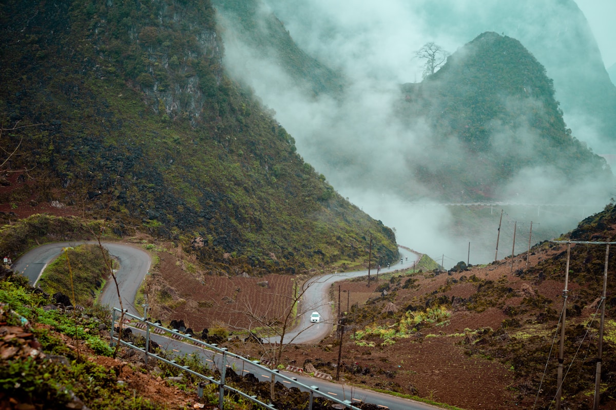
Why Ma Pi Leng Pass is the Most Dangerous Section
Ma Pi Leng Pass is dangerous not because of one single factor but because of the combination of all of them arriving at the same place. The pass runs between Dong Van Town and Meo Vac Town — two of the most interesting stops on the entire loop — so you cannot skip it without missing the heart of the route.
The road itself is narrow. In places two vehicles can barely pass. The corners are blind — you cannot see what is coming. The drop on the outer edge is immediate and extreme. The Nho Que River at the base of the gorge is a thin turquoise line hundreds of metres below you for much of the descent. Guardrails exist in some stretches and are absent in others.
The terrain type matters too. This is the Dong Van Karst Plateau — UNESCO-listed limestone karst landscape. Limestone is a rock that weathers in very specific ways: it creates smooth, polished surfaces when wet, and the road dust that settles on it in dry conditions reduces grip even further. Riders who have only ever ridden on asphalt in cities find the handling completely different here.
Then there is the altitude and the mist. The Dong Van Karst Plateau sits at elevations between 1,000 and 1,600 metres. In the afternoon, particularly from April through October, cloud and mist can move across the road in minutes. A road that had clear visibility at noon can have 10-metre sight lines by 2pm. Riders who leave Dong Van late and are still on Ma Pi Leng Pass at 3pm face a meaningfully different road to the one they planned for.
Leave Dong Van for Meo Vac no later than 8am if possible. The descent of Ma Pi Leng Pass takes 45 minutes to an hour at a safe pace — you want to complete it by 10am before afternoon mist arrives. If it is already misty when you wake up, wait it out at your guesthouse. The road will still be there in the afternoon; the mist may clear by midday. No view justifies riding blind on this road.
The Full List of Risk Factors — What Actually Kills People
Every fatal accident on the Ha Giang Loop involves at least one of these factors, and most involve three or four together. Reading this list is not meant to frighten you — it is meant to give you specific things to control.
Inexperienced Riders on Unfamiliar Bikes
The Ha Giang Loop has a reputation as a destination for backpackers, and many of those backpackers have ridden a scooter in Bali or Koh Samui but have never handled a manual motorbike on mountain roads. The bikes available to rent in Ha Giang City range from battered semi-automatic Honda Wins to newer semi-autos and automatics. The difference in handling between these bikes is significant, and the difference between riding a flat resort road and descending a mountain with a loaded backpack throwing your weight backward is enormous.
Manual gear bikes require you to actively manage engine braking on descents — if you coast in neutral on a long downhill, your brakes alone will not hold the speed and will overheat. This is not obvious to riders who learned on automatics. Several accidents are attributed to riders who did not know to use engine braking on the long descents south of Meo Vac.
Poor Road Conditions
The road quality on the Ha Giang Loop has improved substantially since 2015, but it remains uneven. The main Ha Giang City to Dong Van highway is well-maintained. The side roads and alternative routes — including the popular detour via Ma La Village and Sung La Valley — can include sections of broken tarmac, gravel, and unmade road. If it has rained heavily, washouts are possible on lesser-used routes. Riders who veer off the main loop route to find "quieter" roads may find conditions that their hire bike genuinely cannot handle.
Reckless Speed and Passing
Speed is a factor that riders control entirely themselves. The posted limits on the loop are 40 km/h in mountain sections and 60 km/h on flatter stretches. Many riders do not respect these. On the straight sections between Yen Minh and Dong Van, the road is wide enough that riders feel comfortable pushing 80 or 90 km/h. Then a truck comes the other way on a section that is slightly narrower than expected, or a cow is standing in the road around a blind corner.
Overloaded Bikes
Backpackers carry heavy bags. A 15 kg backpack strapped to the rear of a 100cc Honda Win fundamentally changes the bike's handling — the front wheel becomes lighter, braking distances increase, and the whole bike feels unstable on cambered corners. If you are carrying a full travel backpack, it either goes in a pannier bag on a rear rack, or it goes in a support vehicle, or you reconsider whether you should be self-riding at all.
Riding at Night or in the Rain
Night riding on the Ha Giang Loop is, in my view, simply not something that should happen. The roads have no lighting. Animals, pedestrians, and slow vehicles share the road. A pothole you could avoid in daylight becomes a crash at night. Rain riding, particularly on the approach to Ma Pi Leng Pass, is similarly in a different risk category to riding in dry conditions.
The Specific Spots Where Accidents Concentrate
Accidents on the Ha Giang Loop are not evenly distributed. They cluster at specific points, and knowing those points helps you prepare your mental approach before you arrive at them.
Ma Pi Leng Pass (Dong Van to Meo Vac): The most serious accidents, including the fatal ones I mentioned above, have occurred on this 20 km stretch. The descent from the pass summit toward Meo Vac Town is where the most exposure is greatest. There is a famous "Heaven's Gate" viewpoint near the top — take your photos, then take the descent with complete focus.
The approach to Lung Cu Flag Tower: The Lung Cu Flag Tower marks Vietnam's northernmost point, near the Chinese border in Dong Van District. The road up to the tower is steep and narrow. It is a short detour but the final approach involves a very tight climb that catches out riders who misjudge their bike's power.
Pai Lung / Phai Lung: The road through Pai Lung village is where the 2023 British tourist incident occurred. This section has a long exposed cliff edge without consistent barriers. It is not as famous as Ma Pi Leng but it requires the same respect.
Quan Ba Heaven Gate: The descent from Quan Ba Heaven Gate toward Tam Son Township on the first day of the loop has claimed lives too. Riders who are fresh, slightly overconfident, and still adjusting to their hire bike sometimes push too hard on a road that punishes that.
Night sections between Yen Minh and Dong Van: Riders who cover the loop in three days sometimes find themselves riding after dark on this stretch. The road is better here than on the pass sections, but the lack of lighting and the fatigue from a full day on the bike make it disproportionately dangerous.
The Honest Assessment: Is It Safe Enough to Do?
Yes — but that answer comes with conditions attached that actually matter. The Ha Giang Loop is done safely by thousands of people every year. The risk is real but it is not random. It concentrates around a specific profile of behavior: self-riding with limited experience, ignoring weather conditions, carrying too much weight, riding too fast, and starting the Meo Vac descent too late in the day.
The single change that most reduces your risk is hiring a local Easy Rider driver for the loop rather than riding yourself. An Easy Rider — a local Vietnamese driver who takes you as a passenger — knows the road in all seasons, knows which corners catch out visitors, knows when to slow down without being told. The cost difference between renting a bike and hiring a driver is not large in the context of the overall trip, and the safety difference is substantial. If you have limited mountain motorbike experience, I would put "hire a driver" in the category of things that are not optional.
If you do choose to self-ride: ride an automatic or semi-automatic you have tested before leaving Ha Giang City. Start each day early — on the road by 7am. Stop before midday on the Ma Pi Leng section. Tell your accommodation where you are going each evening. Wear a full-face helmet. Do not ride in the dark.
The Easy Rider drivers who operate out of Ha Giang City are predominantly H'mong and Tay ethnic minority men who have ridden these roads for decades. Some of them were riding the loop before there was a proper road surface. They know every pothole, every slippery corner, every spot where mist typically arrives first. Their local knowledge is not just a comfort — it is a concrete safety asset. Ask your guesthouse in Ha Giang City for a recommendation, or look for licensed operators through the Ha Giang Tourism Department.
Sapa First — Then Ha Giang
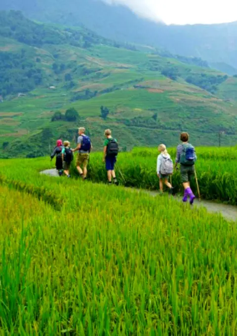
A lot of travelers doing northern Vietnam combine Sapa and the Ha Giang Loop in the same trip. They are different experiences that serve different purposes. Sapa — where we operate — is a trekking destination: Black H'mong and Red Dao villages in the Muong Hoa Valley, rice terrace walks through Lao Chai and Ta Van, homestays in the hills above Y Linh Ho. You walk, you do not ride. Our local guides have been leading these routes for years and know every path.
Ha Giang is a road trip. The landscape of the Dong Van Karst Plateau is geologically different to Sapa's rice terrace hills — more exposed, more dramatic, more stark. The ethnic communities are different too: Hmong people also live in Ha Giang, but you will also encounter Lo Lo, Pu Peo, and Tay minority communities with distinct cultures and textile traditions.
If you are planning to do both: do Sapa first, rest, then travel to Ha Giang. Arriving at Ha Giang after a week of trekking in Sapa means you come fresh to the motorbike route. Arriving at Ha Giang jetlagged or immediately after a long overnight bus from Hanoi, and getting on a bike the same morning, is exactly the condition that produces accidents.
For Sapa treks, we offer guided day tours and multi-day options that cover the core routes in the Muong Hoa Valley. Have a look at our tours below, or message us directly on WhatsApp — we reply within 5 to 10 minutes and can help you plan a northern Vietnam itinerary that puts both destinations in the right order.
Start Your Northern Vietnam Trip in Sapa
 Best Seller
Easy
Best Seller
Easy
Trekking Through Rice Terraced Fields
Walk through Lao Chai and Ta Van villages in the Muong Hoa Valley — led by Black H'mong guides who know every path.
 Very Easy
All Fitness Levels
Very Easy
All Fitness Levels
Sapa Easy Trekking For Seniors
Gentle trails through rice terraces and H'mong villages — suitable for all ages and fitness levels. No experience needed.
What to Do Before You Go to Ha Giang
Preparation is the difference between the loop being a remarkable memory and a medical emergency. These are not generic travel tips — they are specific to the Ha Giang Loop road conditions.
- Decide whether to self-ride before you arrive. If you have ridden a manual motorbike for fewer than 50 hours in your life, or have never ridden on mountain roads, hire a driver. This decision is easier to make from the comfort of planning than from the pressure of a rental shop telling you the bike is available right now.
- Check your hire bike thoroughly. Brakes front and rear, tyre pressure and tread depth, lights, horn, chain tension. Ride it for 20 minutes in Ha Giang City before leaving. If anything feels wrong, swap it. Rental shops in Ha Giang City are competitive enough that you have negotiating power.
- Get proper travel insurance. Standard backpacker insurance often excludes motorbike riding. Read the fine print. Coverage that includes helicopter evacuation is not overkill in this region — it is realistic given how remote the route gets.
- Take a full-face helmet. The open-face helmets available for free at rental shops are not adequate protection for a high-speed fall. Bring your own or buy one in Ha Giang City.
- Plan four days minimum for the loop. Three days is possible but it requires covering distances that mean early starts and late finishes every day, which increases fatigue risk. Four days lets you ride at a pace that matches the road, not the schedule.
- Know the emergency contacts. Ha Giang Provincial General Hospital: +84 219 3866 268. Vietnamese emergency services: 115 (ambulance), 113 (police). Download Maps.me with the Ha Giang region downloaded offline so you can share your location even without mobile data.
The Road Conditions Month by Month
The risk profile of the Ha Giang Loop changes significantly through the year, and knowing what to expect in your travel month helps you prepare specifically.
| Month | Conditions | Risk Level | Notes |
|---|---|---|---|
| January–February | Cold, dry, occasional fog | Moderate | Dry surface is a major advantage. Cold temperatures slow reflexes — dress warmly and expect cold hands on morning starts. Buckwheat flowers bloom around Dong Van. |
| March–April | Warming, dry to early rains | Good | Generally the best riding conditions. Road surface dries fast after any rain. Visibility good. Busy with domestic tourists during Vietnamese holidays. |
| May–August | Rainy season, frequent mist | High Risk | Most accidents occur in this window. The road surface is wet most mornings. Mist arrives early on the Dong Van Karst Plateau. Not recommended for inexperienced riders. |
| September–October | Late rains, harvest season | Moderate–High | Visually the most spectacular time — buckwheat flowers and terraced fields. But September is still rainy. October is the peak tourist season, highest rider volume on road. |
| November–December | Cool, mostly dry, clear | Best Season | Clearest road conditions of the year. Cool mornings — bring layers. Best visibility on Ma Pi Leng Pass. The loop is busy but conditions are as safe as they get. |
How dangerous is Ha Giang Loop — honestly?
Trek Sapa Safely — With the Right Equipment
 Gear Rental
$2/Day
Gear Rental
$2/Day
Trekking Boots Rental
Waterproof ankle-support boots. Cleaned and checked before each rental. Available at 105 Thach Son Street.
 Gear Rental
$2/Day
Gear Rental
$2/Day
Walking Poles Rental
Trekking poles available to rent at $2/day at our office, 105 Thach Son Street. Essential for descents.
Frequently Asked Questions
Reliable official statistics are not published by Vietnamese authorities, but local operators and news reports suggest an estimated 10 to 20 foreign tourist deaths occur annually on the Ha Giang Loop. The number varies year to year depending on weather conditions and tourist volume. Vietnamese local riders are involved in additional fatalities not captured in foreign tourist counts.
Ma Pi Leng Pass between Dong Van and Meo Vac is widely considered the most dangerous section. The road drops several hundred meters on one side with no barrier for stretches, curves are tight and blind, and the surface becomes treacherous when wet or misty. The descent into Meo Vac Town is where multiple foreign tourist accidents have been recorded.
Yes, significantly safer. Hiring a local Easy Rider driver means you are on a bike with someone who knows the road in all weather conditions, understands the blind corners, and has experience with the mountain driving style required. Most fatal accidents involve self-riders who have limited motorbike experience and are unfamiliar with mountain roads. If you have not ridden a manual motorbike in mountain conditions before, do not ride solo on the Ha Giang Loop.
The main causes are inexperienced riders on unfamiliar motorbikes, excessive speed on steep descents and blind corners, failure to wear helmets or wearing inadequate helmets, wet or foggy road conditions where riders cannot judge the road surface, overloaded bikes with heavy backpacks affecting balance, and fatigue from long riding days. Alcohol is also a contributing factor in a number of incidents.
The road surface has improved in many sections compared to ten years ago, and guardrails have been added in some of the most exposed stretches near Ma Pi Leng Pass. However, tourist numbers have grown significantly, meaning more inexperienced riders are on the road each year. The net safety picture has not improved dramatically. Mist and rain remain year-round hazards that cannot be engineered away.
Before riding the Ha Giang Loop: rent a semi-automatic or automatic bike if you are not confident with manual gears, test your bike for 30 minutes before leaving Ha Giang City to check brakes and lights, wear a full-face helmet — not a bicycle helmet — and bring gloves and a rain jacket. Start each day early to avoid afternoon mist. Stop if visibility drops below 20 metres. Never ride at night on the mountain sections. Tell your accommodation each day where you plan to reach that evening.
Being a passenger reduces your workload but does not eliminate your risk. In April 2026, 19-year-old British tourist Orla Wates died on the Ha Giang Loop as a pillion passenger — she was not the driver when the accident occurred. When choosing to ride pillion, you transfer your safety entirely to the driver. The key questions to ask: Has this driver done the full loop before, including Ma Pi Leng Pass? In what weather conditions are they experienced? A local Easy Rider driver with years of experience on these specific roads is a meaningfully safer choice than another traveller who has only ridden in flat terrain. Never accept a pillion ride with someone you have not assessed, and insist on a full-face helmet regardless of who is driving.